 ULURU. HEXAGRAM. ULURU. HEXAGRAM.
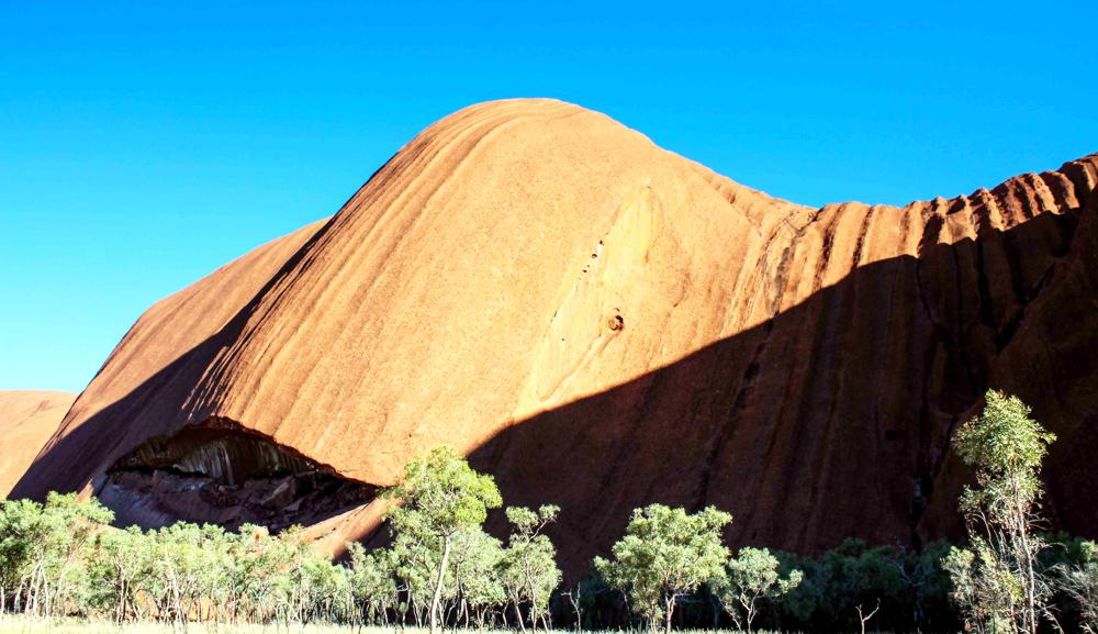
Uluru is located almost in the center of Australia, and is considered one of the most amazing sights on our planet. Mountain is covered with numerous legends and secrets, not only ancient but also modern.
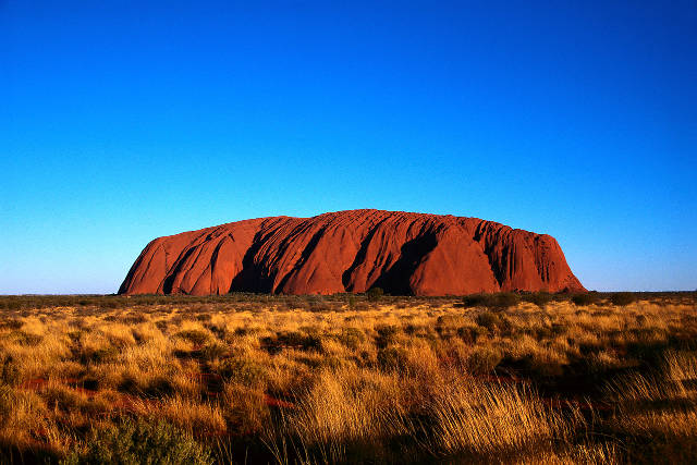
Uluru is a homogeneous monolith on 350 meters protruding from the ground. Its length is more than- 3.5 km, width is - 3 km. Sacred rock is composed of red sandstone, which has a unique structure and special properties owing to which that rock, depending on the light changes color. Amazing game of color does not stop all day. At dawn silhouette of the mountain obtains dark purple hue. In the afternoon, illuminated with bright sun, Uluru becomes purplish-red or flash with pink and it becomes golden in noon.
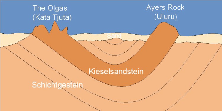 Among geologists debates about the origin of this rock formation do not end till now. By all measures, it should not be here. Rock of Uluru is only a small, visible part of the "iceberg", the bulk of the monolith is under the ground in the midst of loose sediment. Among geologists debates about the origin of this rock formation do not end till now. By all measures, it should not be here. Rock of Uluru is only a small, visible part of the "iceberg", the bulk of the monolith is under the ground in the midst of loose sediment.
There are suggestions that the rock massif of Uluru underground is connected with another mysterious formation located nearby - Kata Tjuta rocks or as they still are called Olga in honor the daughter of Russian Emperor Nicholas the First.
According to the official version Uluru appeared about 700 hundred million years ago from sediments at the bottom of almost dry lake Amadius.
It is assumed that in the middle of the lake formerly stood a huge island, which gradually destroyed, and its parts compressed at the bottom of giant reservoir.
Thus, for a long period of time formed a rock Uluru in the heart of Australian continent.
 Uluru is sandstone. Uluru is sandstone.
This opinion today is increasingly questioned by many authoritative experts who claim that the rock could not be formed with this way its composition differs from the surrounding rocks.
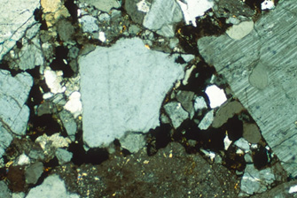
Having examined the composition of sandstone from which consists the monolith under the microscope, geologists determined that the specific minerals in the sand grains look rough, uneven and vary in size. These features indicate on their rapid movement and deposition of sand just before it had time to wear out and become smooth.
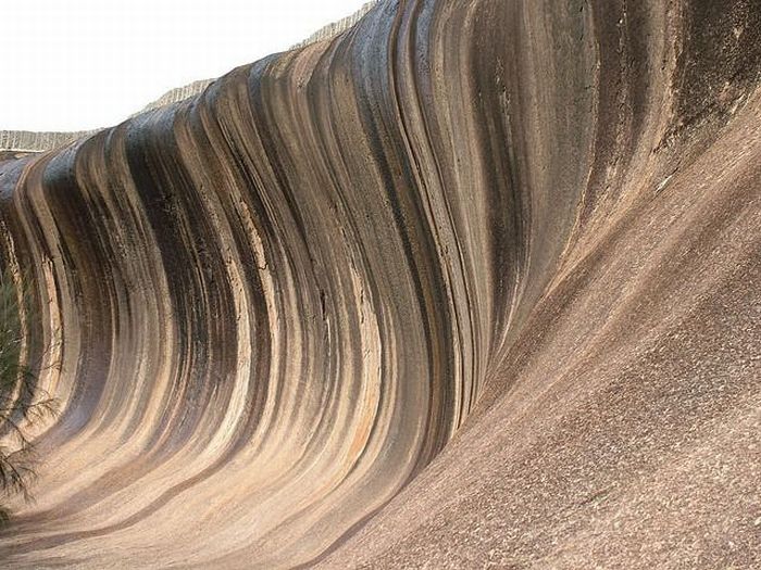 Uluru rock -wave is suspension flow or as it is called - turbid stream moves with the speed up to 113 km / h and consists of sediments similar to gruel. Uluru rock -wave is suspension flow or as it is called - turbid stream moves with the speed up to 113 km / h and consists of sediments similar to gruel.
Just such flow had to carry all this sand, 5500-6100 m in thick, on the distance equal to approximately 120 km, and put it in the form of sandstone layers of Uluru mountain during a few hours!
And really if you look at some monolithic formations of Uluru mountain it is very difficult to escape the feeling that it's just frozen stone waves when it was liquid rock.
These data refute the evolutionary origins of Uluru and vice versa are in good agreement with the traditions of Australian aborigines, who say that Uluru appeared just for a few days.
 Aboriginal rock paintings of people in the caves of Uluru have lived here for more than 10 000 years, and the rock of Uluru is the central object of their worship. Aboriginal rock paintings of people in the caves of Uluru have lived here for more than 10 000 years, and the rock of Uluru is the central object of their worship.
At the bottom there are many caves with ancient rock paintings. Mountain is fanned with plenty of myths and legends, according to one of which Uluru was created by ancient giants, according to another one rock emerged in the place where the battle took place between several tribes.
As a result of the battle, two tribes - people-snake (again reptiles) and the people - the hare kangaroos were completely annihilate. Uluru in the morning rose from the ground and absorbed the souls of the dead soldiers. Since then it is believed, who will take the particle of Uluru will have trouble.
Thus, currently to determine reliably how and whereby Uluru mountain appeared is impossible.
 Rock formations on Uluru are unusual origin. Uluru being the main shrine for all aboriginal people does have some force not amenable to scientific understanding. Rock formations on Uluru are unusual origin. Uluru being the main shrine for all aboriginal people does have some force not amenable to scientific understanding.
According to local legends, Uluru is a door between the world of humans and the spirit world. Aborigines believe that this huge, red rock appeared here before "Eternal Period of Dreams" the basic concepts of the local population cult, which means something like a parallel non-material world of spirits and mythical ancestors, always existed and laid the foundations of human behavior.
According to indigenous Australians everything in this world is filled with spiritual power and are associated with a single person in familial mythological element. A rock Uluru, in this system of the universe has a key role, serving as a bridge between two worlds. Near the rock natives performed their rites, and today their attitude towards Uluru has not changed. Not one native dares to climb on its top, as this is considered by terrible sacrilege, capable to incur the wrath of spirits on human or ancestors, from the same "Eternal Period of Dreams."
According to another legend, Uluru is a landmark on one of the "dream paths" laid Aboriginal ancestors, when the Earth was forming. From this point of view we look at Uluru, as to great landmark to destroy which is impossible. If for "trail of dreams" take the lines connecting the key points of the system, everything converges.
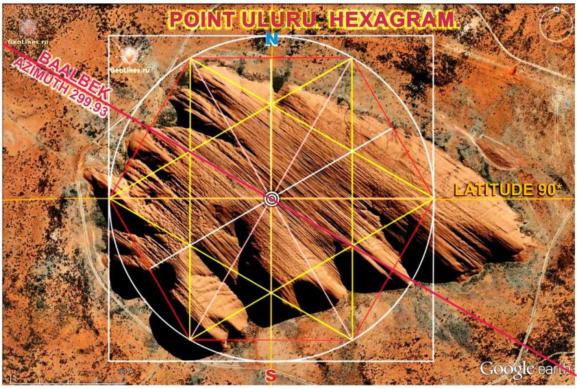 Orient hexagram to the cardinal points. Orient hexagram to the cardinal points.
In this position, we will see that azimuth of Baalbek, with an error 0.07, coincides with the axis of hexagram, and differs from the north-south axis on 60 degrees.
Besides, the distance between Baalbek and Uluru is 11960 km or 107.6 degrees. This means that together with Uluru, Baalbek divides the large circle in the ratio of the pentagram. Error is -0.4 *.
Together with Baalbek on the distance 11951 km or 107.4 * from Uluru is removed Solomon temple. And in the point of Baalbek directions to Solomon temple and Uluru are perpendicular. See article "BAALBEK HEXAGRAM."
Line Uluru - Baalbek has many amazing properties, many of which are described in the article "LOCATION OF ANCIENT STRUCTURES IN THE GOLDEN SECTION.”
PART 2 ".
| 
 Sensational! Tens of thousands of unknown geoglyphs have been found in the Sahara.


