 TIWANAKU. HEXAGRAM. TIWANAKU. HEXAGRAM.
Tiwanaku is the oldest, the largest and the most mysterious city in South America, which according to legend was built by the gods. All myths, confirming with geographical data and archaeological finds indicate to the southern shore of lake Titicaca, as on cradle both of human civilization, in South America and the gods themselves. Just from here, as the legend says, the colonization of Andes after the Great Flood began, just here was the abode of gods, headed by Viracocha; just here were given to the founders of the Old Empire knowledge, route maps and the Golden wand, with which they determined position of "the Earth navel".
With historical exclusivity Tiwanaku agree majority of researchers and this gives birth to various, sometimes the most fantastic version of its origin.
With that the construction was carried out in Tiwanaku by gods in the flesh, agrees a supporter of paleo-contacts theory, Z. Sitchin.
X.S. Bellamy believed that this "holy city" in general is the oldest city in the world and it was built 250,000 years ago! Arthur Poznansky, who has a lot of merits in the study of Tiwanaku, claimed that the Eternal City appeared 17,000 years ago and is "the cradle of American man."
Famous Norwegian scientist Thor Heyerdahl believed its inhabitants as the creators of the latest huge statues on the polynesian island Easter. Some researchers believed that the construction of Tiwanaku involved Nordic Vikings. Aymara origin living in the neighborhood with Tiwanaku, even associated with the biblical Adam (if to believe to one of the old Bolivian authors, Adam spoke Aymara!). Even the Nazi proclaimed Viking by their predecessors, raised claim to Tiwanaku.
 Scientists believe that Tiwanaku culture was born approximately in 2000 - 1500 years. BC In the period between 300 BC and 300 AD city of Tiwanaku was a religious center in which were performed the pilgrimages. Based on materials of excavation foundation of settlement is dated 1500 BC. In II - IX centuries of new age. Scientists believe that Tiwanaku culture was born approximately in 2000 - 1500 years. BC In the period between 300 BC and 300 AD city of Tiwanaku was a religious center in which were performed the pilgrimages. Based on materials of excavation foundation of settlement is dated 1500 BC. In II - IX centuries of new age.
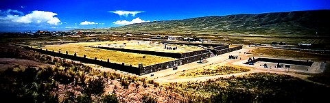
4 main buildings of Tiwanaku are located on a relatively small area with measure approximately 500 meters x 1000 meters.
One of them - Akapana - represents itself a 15-meter stepped pyramid with a base width in 230 meters. It is believed that its name is translated as "the place where people die." From Akapana preserved only hill with a platform of base. Although once edges of the pyramid were paved with large slabs of andesite, and at the top was located a pool of cruciform shape each side of which was not rectangular, and resembled a three-stage pyramid similar to Indian cross "Chakan".
 According to incan legends, the city appeared very long time only in one night, and belonged to their supreme god Viracocha. Once the city was called Taypikala or Center of the world according to others data Vinaymarka - eternal city and now its name is Tiauanako (Tiahuanaco), or TiuaNako (Tiwanaku) - dead city. There is speculation that this place was called "the center stone." In short,center of the world or the key point is a landmark in the system of ancient monumental buildings (SDMS). This concept likely more accurately reflects the purpose of this immense complex. According to incan legends, the city appeared very long time only in one night, and belonged to their supreme god Viracocha. Once the city was called Taypikala or Center of the world according to others data Vinaymarka - eternal city and now its name is Tiauanako (Tiahuanaco), or TiuaNako (Tiwanaku) - dead city. There is speculation that this place was called "the center stone." In short,center of the world or the key point is a landmark in the system of ancient monumental buildings (SDMS). This concept likely more accurately reflects the purpose of this immense complex.
 Orient hexagram along the cardinal points. Orient hexagram along the cardinal points.
In this position azimuth of Baalbek which is equal to 59.31 * with the error -0.69 * coincides with the angle of hexagram 60 *
Consider this combination in detail.
Let's start with the fact that such orientation (according to the angle 60 *), azimuth of Baalbek has more in two key points, in Samaipata and Uluru. These two objects also have a direct link with Tiwanaku and Teotihuacan, which are equidistant and in the golden section from Baalbek. See article "LOCATION OF ANCIENT STRUCTURES IN THE GOLDEN SECTION. PART 2 ".
In this article, we told about the fact that the line Uluru - Baalbek, is perpendicular to the line of Tiwanaku - Teotihuacan, but here we see that azimuth of Baalbek is close to 60 *.
Besides, the listed objects together with Great Pyramid (GP), Lhasa and Easter island set 5-and 10 * meridional network in which meridian of GP is conditional meridian zero meridian. See article "GEODESY OF MERIDIANS."
In this combination it can also be included azimuth of Por Bajin ,which is equal to
15.13 *. A distance from Tiwanaku to Por Bajin is 16009 km or exactly 144 *. See article "PENTAGRAM IN LOCATION OF KEY POINTS OF SDMS.".
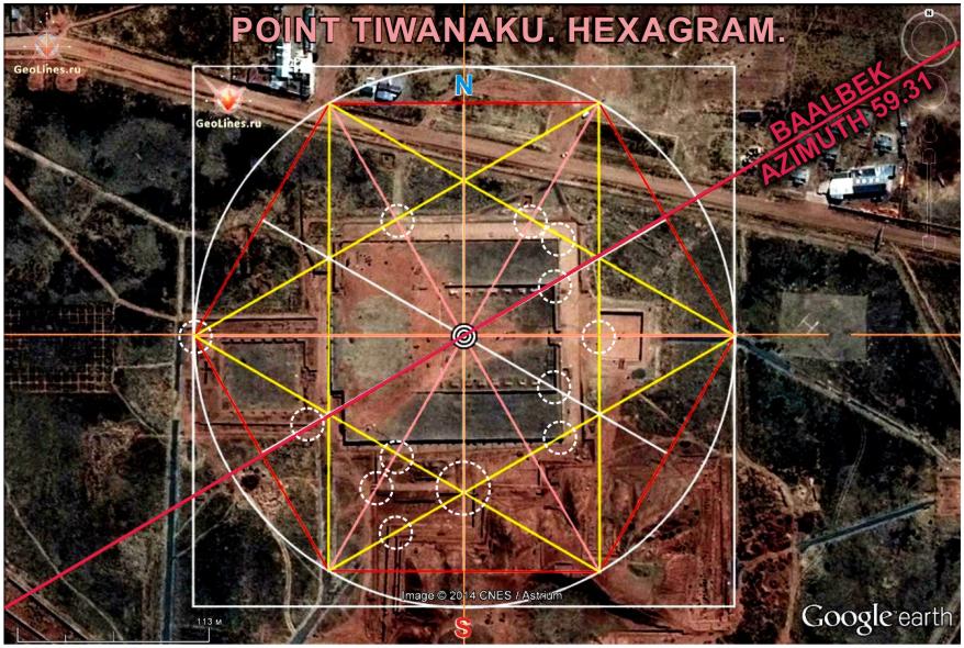 Now look at the image once more. Now look at the image once more.
In this case hexagram is centered on the stone idol installed in the temple Kalasasaya.
At that the square in which is inscribed the circle of hexagram, is inscribed within the boundaries of the temple, to the left from Kalasasaya. At this scale of hexagram, we see some clear laws related to the layout of all complex.
| 

 Sensational! Tens of thousands of unknown geoglyphs have been found in the Sahara.


