
|
Publications HISTORICAL GEODESY© GeoLines GEODESY OF HEXAGRAM
It is possible to tell with confidence, that up to nowadays hexagram remains the most known and demanded symbol. But not many people know that besides sacral properties hexagram possesses also absolutely concrete geodetic properties connected with orthogonal proection of globe centered by pole. As it is known, in such projection the equator plane will be as plane of designing which is represented in the form of a circle. All other latitudes also will be circles of the smaller diameter which centre is the pole, in our case Northern. Geodetic properties of hexagram for the orthogonal projection centered by pole are expressed in that they allow constructing very precisely all basic latitudes and even some known points without calculations only by means of compasses and ruler.
Further from points of intersection of a
straight line (axis x) with equator we will draw two more circles of
the same diameter. Intersection points of these circles with equator
are tops of hexagram from which it is possible to construct at once
following latitudes: 60th latitude is a circle included in equilateral triangles forming hexagram. 30th latitude is a circle included in a
hexagon formed by hexagram tops. As the Great pyramid (GP) lies on 30th latitude we having chosen its meridian for axis Y, we will receive at once a point of its disposition in the projection. It will be crossing of a vertical line (meridian GP) with the hexagon side. 15th latitude is a circle included into 12- angle.
Latitude 40° is a circle passing through intersection points of a square, included in equator, with the circles constructed from intersection points of axes Х and Y with equator. To construct latitude 20 °, it is necessary to draw a line (horizontal red) through crossings of diagonals 45° with hexagram (see drawing) and a line (vertical red) constructed from 12 angles. Crossing of these two lines will be a point lying on 20th latitude (bright- green circle). For construction of 50th latitude we will draw circles from intersection points of axes Х and Y with equator. From the intersection points of these circles we will construct the additional circles which crossings with the square sides included in 45th latitude is 50th latitude. All previous constructions of latitudes are display of purely mathematical properties of hexagram. Construction of the Polar circle and Tropics cannot be connected with hexagram as their latitudes are formed thanks to an inclination of a terrestrial axis. However it is not so. Let's draw a line through intersection point of axis +Y with equator and intersection point of average line of a hexagram triangle with 45th latitude. Crossing of this line with diagonal 45° is a point lying on a polar circle. Having drawn a line through this point and intersection point of axis X with equator we will receive intersection point of tropic with the second diagonal 45°. In the previous article the assumption
about interrelation between the Great Pyramid and Stonehenge through
distances has been told. Length of arch on a globe surface between GP
and Stonehenge is (3597км.) Is approximately equal to length of arch
between meridians of these historical constructions on equator
(3668км.). The orthogonal projection gives some more arguments in favor
of this assumption. The matter is that the point a Stonehenge lies
precisely on the square side included into 30th latitude, i.e. in
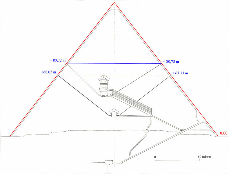
latitude GP. Crossing of side of this square with the line (red) passing through crossing hexagram side and intersection point of hexagram triangles with axis X - i.e. with meridian GP will give exact position of a Stonehenge in an orthogonal projection. Hexagram allows defining place in the orthogonal projection of Easter Island. For this purpose we will construct 6-angle of hexagram included into 15th latitude and we will draw a straight horizontal line through intersection points of 2 hexagrams. Crossing of this line with side of 6- angle is point of Easter Island. As our projection is centered in the North Pole and Easter Island is in Southern hemisphere actually, the received point, displays an axis passing through an island of Easter under right angle to a plane of equator. By this reason in the given projection the point gets on the western coast of the North America. So that to see a real point it is necessary to look at an equator plane from the other hand, i.e. to center a projection across the South Pole. But the most surprising results gives combination of drawing of Great pyramid with an orthogonal projection. If to combine the top GP on the drawing with point of GP in projection and the pyramid basis to include in its latitude we will see so much coincidence that their casual character causes big doubts. At such position of the pyramid, the roof top of "the Chamber of the tsarina» marks the centre of co-ordinates, i.e. the North Pole. Mines - "the air ducts" leaving the chamber mark intersection points of the Polar circle with average lines of hexagram triangles. If to draw a horizontal line through points of an exit of these "air ducts" on the pyramid surface, it will pass precisely through crossing of 2 triangles of hexagram and roof top of "the Chamber of Pharaoh». The mine leaving from «chamber of t Pharaoh» under angle 45 degrees coincides with diagonal and passes through crossing of 2 hexagrams. As the chamber is displaced from the central axis exactly so, as much as necessary, the second mine under the necessary corner, also passes through crossing of 2 hexagrams. The horizontal line, traced through the points of the mines exit of «chamber of Pharaoh» on the pyramid surface it marks: * Crossing of the pyramid borders with
diagonals. Pyramid borders pass through: * Crossing of two triangles of one
hexagram with average lines of triangles of the second hexagram turned
on 30 degrees. The descending corridor and not complete
chamber describe the Polar circle, and the ascending corridor marks the
circle traced from the point of axis +Х intersection with equator. The Big gallery which slope angle is connected with hexagram has not stood aside also. As the proof a dark blue dashed line parallel to the big gallery can serve. This line is traced in the other place through the crossing of triangles of one hexagram with the average line of triangle of the second hexagram and axis crossing-Y with 45th latitude. This line has also other crossings shown in drawing lower. In other words it is possible to tell that the big gallery is parallel to the line having a direct relationship to hexagram and to a pyramid. In terms of the aforesaid, it is possible to assume that in the Great pyramid are in addition put also geodetic parameters of the Earth. More and more the facts confirm that the Great pyramid is a huge geodetic sign, the central reference point, and the passport in which basic data about the Earth and its vicinities are written down. Who had created this sign and for whom the information is intended remains as riddle for today. One more interesting fact is connected with the pyramid. When the question had been solving where to pass a zero meridian the Great pyramid along with Greenwich and Paris was among pretenders. Probably, if the zero meridians passed through the pyramid everything would stand on the places. But may be on the contrary, the zero meridians did not pass through GP just because then everything would stand on the places.
The using of article materials the direct reference is obligatory. Author: GeoLines |
 Sensational! Tens of thousands of unknown geoglyphs have been found in the Sahara.
- In Moscow will bring a lot of the Antikythera mechanism.
- MOVING THE MEGALITHS – THE PROFANITY CONTINUES
- HEAVENLY CASTLE TAKEDA.
- RIDDLES PLATEAU RORAIMA.
- The Gospel of Judas
- At Nazca found beheading scene
LAST COMMENT
-
Все таки версия , что это все ... - пишет undefined в разделе ВПЕРЕД В ПРОШЛОЕ
-
Пентаграмма это суть эфиного п... - пишет undefined в разделе ВПЕРЕД В ПРОШЛОЕ
-
No problems. Just give a link ... - пишет undefined в разделе ONWARD TO THE PAST
-
Самый простой способ - это аму... - пишет undefined в разделе ВПЕРЕД В ПРОШЛОЕ
-
Документированный древний мето... - пишет undefined в разделе ВПЕРЕД В ПРОШЛОЕ
-
Документированный древний мето... - пишет undefined в разделе ВПЕРЕД В ПРОШЛОЕ
-
The Documented Ancient Constru... - пишет undefined в разделе ВПЕРЕД В ПРОШЛОЕ
-
Обычный выход расплава флюидол... - пишет undefined в разделе ВПЕРЕД В ПРОШЛОЕ
19.01.2019 Effective ways to improve health
Комментарии: 0
19.01.2019 Drink mineral water
Комментарии: 0
19.01.2019 Red fruits charge antioxidants
Комментарии: 0


