
|
News News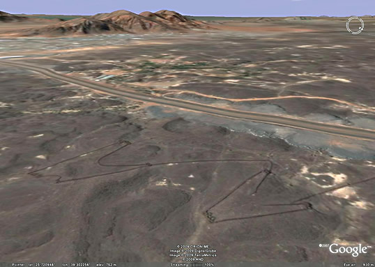
For nearly a century, archeologists have routinely used aerial photo-graphs as a key tool for discoveries and investigations. In western Europe, the discovery through aerial reconnaissance oftens of thousands of previously unknown sites has transformed the way the past is interpreted and explained. In discussions of archeology, aerial views are often far more informative than ground photographs because the aerial views show the whole site within its geographical and environmental context, and they often show patterns too subtle or confusing to be recognizable on the ground. In the Middle East as a whole, there is a growing awareness of the value of this technique, particularly given the volume and complexity of remains and the need to balance preservation with rapid industrial development. Jordan has instituted and supports a program of aerial archeology, to which I have contributed. Recently, however, archeologists have begun to use the satellite imagery publicly available since the launch in 2005 of Google Earth, particularly since its gradual incorporation, beginning in 2007, of high-resolution images. As a result, over some Arab countries—Jordan, Syria and Lebanon particularly—the resolution of available images is now generally high enough to conduct reliable, general archeological surveys. Thanks also to the strong archive of historical aerial photographs from these regions, many dating from World War i to 1948, the new information can often be compared to the more distant past. READ MORE |
 Sensational! Tens of thousands of unknown geoglyphs have been found in the Sahara.
- In Moscow will bring a lot of the Antikythera mechanism.
- MOVING THE MEGALITHS – THE PROFANITY CONTINUES
- HEAVENLY CASTLE TAKEDA.
- RIDDLES PLATEAU RORAIMA.
- The Gospel of Judas
- At Nazca found beheading scene
LAST COMMENT
-
Все таки версия , что это все ... - пишет undefined в разделе ВПЕРЕД В ПРОШЛОЕ
-
Пентаграмма это суть эфиного п... - пишет undefined в разделе ВПЕРЕД В ПРОШЛОЕ
-
No problems. Just give a link ... - пишет undefined в разделе ONWARD TO THE PAST
-
Самый простой способ - это аму... - пишет undefined в разделе ВПЕРЕД В ПРОШЛОЕ
-
Документированный древний мето... - пишет undefined в разделе ВПЕРЕД В ПРОШЛОЕ
-
Документированный древний мето... - пишет undefined в разделе ВПЕРЕД В ПРОШЛОЕ
-
The Documented Ancient Constru... - пишет undefined в разделе ВПЕРЕД В ПРОШЛОЕ
-
Обычный выход расплава флюидол... - пишет undefined в разделе ВПЕРЕД В ПРОШЛОЕ
19.01.2019 Effective ways to improve health
Комментарии: 0
19.01.2019 Drink mineral water
Комментарии: 0
19.01.2019 Red fruits charge antioxidants
Комментарии: 0


