 NAN MADOL. HEXAGRAM. NAN MADOL. HEXAGRAM.
Among of many Micronesian islands scattered in the Pacific Ocean between the equator and the Tropic of crayfish, there is a small volcanic island in the eastern part of Caroline islands called Ponape. It occupies the area in 303 square km, and could easily fit within Moscow ring road. Despite of this, there is a capital of the whole country - Micronesia, and the island itself is the largest of the constituent of the State. The island is surrounded with almost continuous coral reef, which has several passages to the open sea.
Around Ponape is scattered many of small atolls and islands, on one of which under the name of the Theme is situated the object which is even more well -known than the island - Nan Madol itself ,a complex of ancient megalithic structures.
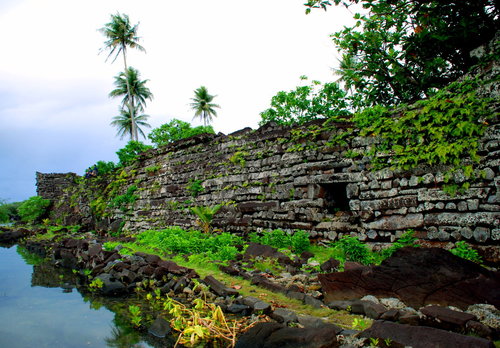
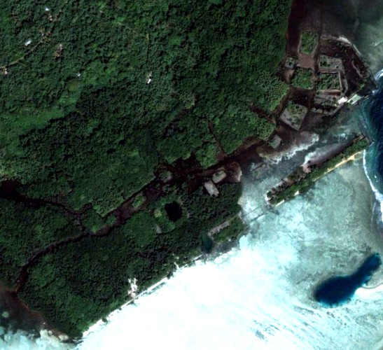 Nan Madol is "Venice" of Pacific Ocean and is one of the greatest mysteries of our time. The complex consists of 92 (!) of man-made islands, erected on a coral reef, and occupies the area of about 130 hectares. The length of some islands comes to hundreds of meters. They are composed of hexagonal and octagonal huge basalt columns weighing from one to ten tons. More precisely: of the columns as from beams are stacked walls of islets. And their internal space is filled with coral rubble. The thickness of the layer of coral rubble ranges from 2 to 3 m, that allowed possible to maintain the interior of the man-made islands dry even during tides. Nan Madol is "Venice" of Pacific Ocean and is one of the greatest mysteries of our time. The complex consists of 92 (!) of man-made islands, erected on a coral reef, and occupies the area of about 130 hectares. The length of some islands comes to hundreds of meters. They are composed of hexagonal and octagonal huge basalt columns weighing from one to ten tons. More precisely: of the columns as from beams are stacked walls of islets. And their internal space is filled with coral rubble. The thickness of the layer of coral rubble ranges from 2 to 3 m, that allowed possible to maintain the interior of the man-made islands dry even during tides.
For strength of foundation of many islands column are make double. Each of the parts is fitted to each other and fastened with the cross bars, cross-pieces. Many of the "fixing" stones weigh more than 30 tons! Long basalt beams, stacked in piles as huge sacrificial fires, soar to a height of 9, and in some places even up to 18 meters - that is, to the height of a seven-story building. But it is not just the stacks but the walls of giant structures. The wall thickness is up to 4 meters.
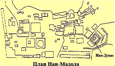 The more impressive is the largest construction of Nan Madol - Nan Duvas. It is surrounded by two concentric walls, between which there is moat, filled with sea water; in the middle of construction there is pyramidal mound. The walls reach a height of more than 7 meters and built of blocks - megaliths of crystalline basalt; some of them weigh up to 50 tons and have a length of 6 meters. The more impressive is the largest construction of Nan Madol - Nan Duvas. It is surrounded by two concentric walls, between which there is moat, filled with sea water; in the middle of construction there is pyramidal mound. The walls reach a height of more than 7 meters and built of blocks - megaliths of crystalline basalt; some of them weigh up to 50 tons and have a length of 6 meters.
Who created all these? Who and why was it necessary to put hundreds of thousands of basalt blocks in stacks, just amused with multi-ton swingers like children's blocks? And to do this is not even on the island itself, but directly in the waters of Pacific Ocean ...
According to the official version, Nan Madol was the ceremonial and political place of dynasty Co-Delyur which combined population of Ponape in ancient times. Oral evidence and archaeological studies indicate that Nan Madol was an outstanding political and religious center until the 15th century AD, when collapsed centralized system of local empire. Although the "empire", of course, it is difficult to call, because society has not risen from the primitive level.
In local museum, you can find items only predominantly made of wood and bone. And the population of the "empire", according to historians, is not more than 25 thousand people (compared with all the modern population of Micronesia and now only 5 times more).

Фото Sven Mueller |
By all measures, Nan Madol is incredible structure and a simple analysis shows that the islanders could not create it.
However, they do not pretend on it.
Aboriginal legends say that the creators of Nan Madol were two god-king - and Olosope Olosipe who arrived by boat from west.
As the legend goes, these "wise and holy men" built four capital on the island, and then left them.
Remains of the settlements are found by archaeologists! Nan Madol was also built by them only as a fifth city.
After climbing to the top of a high mountain, and Olosopa Olosipa surveyed the island and chose the place for its construction.
Looking into the blue of Pacific Ocean they saw underwater city of the gods, and took it as a sign that their city they should build in this place. Therefore, Nan Madol is built as a "mirror image" of its sank fellow.
Photo Sven Mueller .
Sunken "city of the gods", called in the legend Hanimveyso also is not fictional. In course of work on preserving of local archaeological heritage, led by Dr. Arthur Sachs from the Ohio State University, was carried out detailed surveying of large areas of Nan Madol, which confirmed the existence of numerous underwater ruins, including those located in very large depths.
Thus, we have another giant megalithic structure on a small island in the Pacific Ocean, with a clear plan, the occurrence of which in this point seems unsolvable mystery.
However, if we consider the Nan Madol, as a benchmark, then a lot of things stand on their places. For example, it is clear for what is needed massiveness - the basic layout is not destroyed and the lines are still visible. At sea, possibly build, so that contours did not grow with vegetation and maintained its benchmark functions.
Our studies have shown that Nan Madol by virtue of its location has a connection with the movement of Venus and Mercury, being on the line of their transits (See article "NAN MADOL AND VENUS TRANSIT IN 2012").
And as well a direct link with the base points of the system of ancient structures .
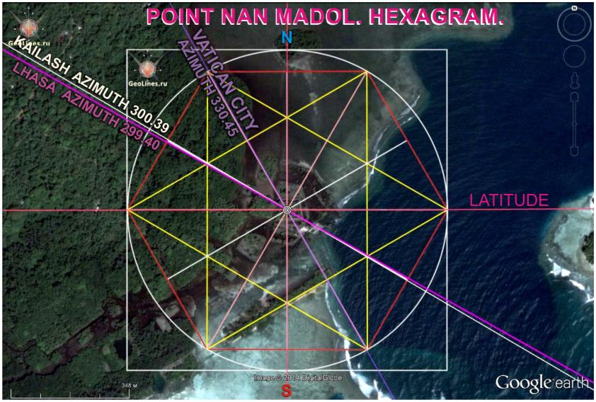 Research of directions to the main object of the system, from the point of view of regular geometric angles yielded surprising results not leaving doubts that Nan Madol is at least a major landmark and a key point of the SDMS. Research of directions to the main object of the system, from the point of view of regular geometric angles yielded surprising results not leaving doubts that Nan Madol is at least a major landmark and a key point of the SDMS.
But first things first. Let's start with hexagram, which orient to the cardinal points. In this position, we obtain with the error + 0.45 degrees azimuth of Vatican, as well with accuracy of + 0.39 azimuth of sacred Mount Kailash.
With accuracy of -0.6 in this combination participate the direction to Lhasa azimuth of which is equal to 299.4 degrees. Thus, the directions to Kailash and Lhasa in the point of Nan Madol differs exactly on 1degree.
It is interesting that in the point of Baalbek azimuth of Vatican is 299.94degrees, i.e. differs from azimuth of Nan Madol on 30 degrees, and is equal to azimuth of Kailash and Lhasa with a small errors. And this is one of the moments binding Nan Madol and Baalbek, which lie relatively to each other in the golden section.
| 
 Sensational! Tens of thousands of unknown geoglyphs have been found in the Sahara.


