
|
Publications THE ALIGNMENTS SYSTEMUNDERWATER ANTLANTIS?
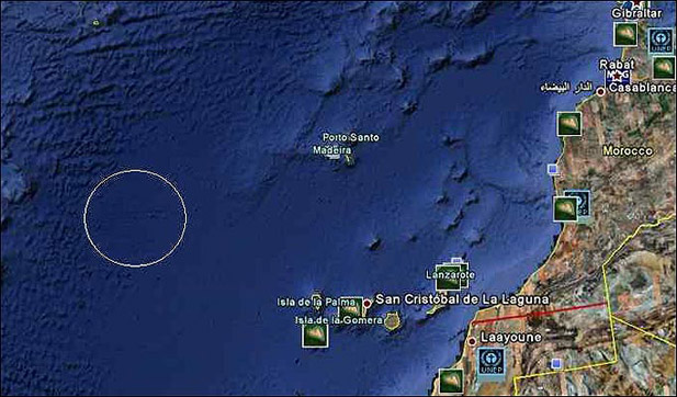
Using the software Google Ocean, which
uses combination of satellite imagery and the most recent data of
Marine Research, naval engineer Bernie Bamford found at the bottom of
the Atlantic Ocean right rectangle which covers an area roughly equal
to the Moscow region. He noted that the topography of the ocean at this
place remines very much the scheme of modern cities, "as if it was
created a human hand." A net of intersecting lines resembling
the configurations of the streets, is located in 1000 km from the coast
of northwest Africa near the Canary Islands. Experts in the field of
Atlantis research confirmed that the object is located in one of the
most probable place of legendary island. - This is a very interesting
observation, - says Alexander Voronin President of Russian Society of
Atlantis problems research - Using these technologies, aerial and
satellite photos were found underwater man-made objects near Bahamas,
near the western coast of Cuba and elsewhere. The underwater object is located just in
North Atlantic - so the observed area may be quite connected with the
ancient mysterious civilization, - says Vladimir Voronin. According to the curator of historical archeology at New York University, Dr. Charles Orser, finding deserves the most fixed attention, despite of the fact that it may be purely geological formation. Google officials immediately lowered
everybody on the land having declared that the these lines formed on
the ocean floor had appeared because of the sonar which descended from
research vessels. "What we see are simply false images
formed as a result of information collection... Bathymetric data or
those on the seabed, often collect with special vessel with sonar ...
Along the way of these boats movement just such lines are produced in
the form of reflection. Between these lines there are obscure spaces,
but it only shows that we still know few about the oceans "- was told
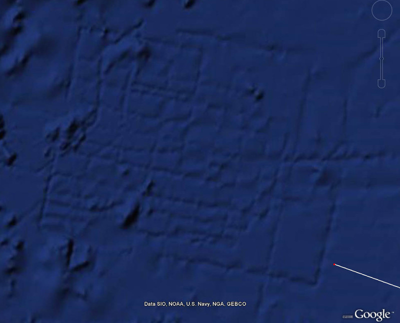
by Google. But not everything is so simple. Almost
three years have passed and passions about the identity of the object
do not cease. If these are errors of location at standing patrol the question arises with what purpose this place in the open ocean is so closely examined? Why is the huge area of the water, about 21 thousand square kilometers, so suddenly carefully studied and with civilian vessel? Sobolle- one of
the forum LAH participants having decided to test the hypothesis about
that the underwater object "Antlantida" is the remain of large ancient
construction carried out retrographic analysis of satellite images.
Here's what turn out of it. Satellite photo image is taken as base collapsible provided by the users of Google Earth. It is logical to assume that the object is either technical artifact made with recording means or grooves of correct form of gigantic size, about what, in particular, say directly treatments light and shadow images.
For convenience we orientate the image correctly and begin processing.
We get rid of the specifics of the seabed, using not distort filters and remove sharp objects such as "hill", "crack." These objects can be either alien or emerge later as a result of natural movement of tectonic plates. We obtain the following very impressive results.
Combination of several filters and rules for researching patterns of similar graphic sprite bars, turned out clear hints to "fuzzy" channels. That is, they have a beginning but have no end. Obviously missing elements were added most likely disappeared as a result of the seabed erosion. That is quite possible. If these are giant canals then they must have at least two things the beginning and the end. During the processing were used a lot of layers ( more than 60), which list has no sense. The reliability of this step in the reconstruction is not so clear and the probability of correct identifying the authors estimated as 70-75%. That is quite a lot for the given case. It was the longest stage of analysis so they had to meticulously decide where the visible piece of the canal is and should it be considered "this deepening " as fragment of disappeared construction. Such result was got:
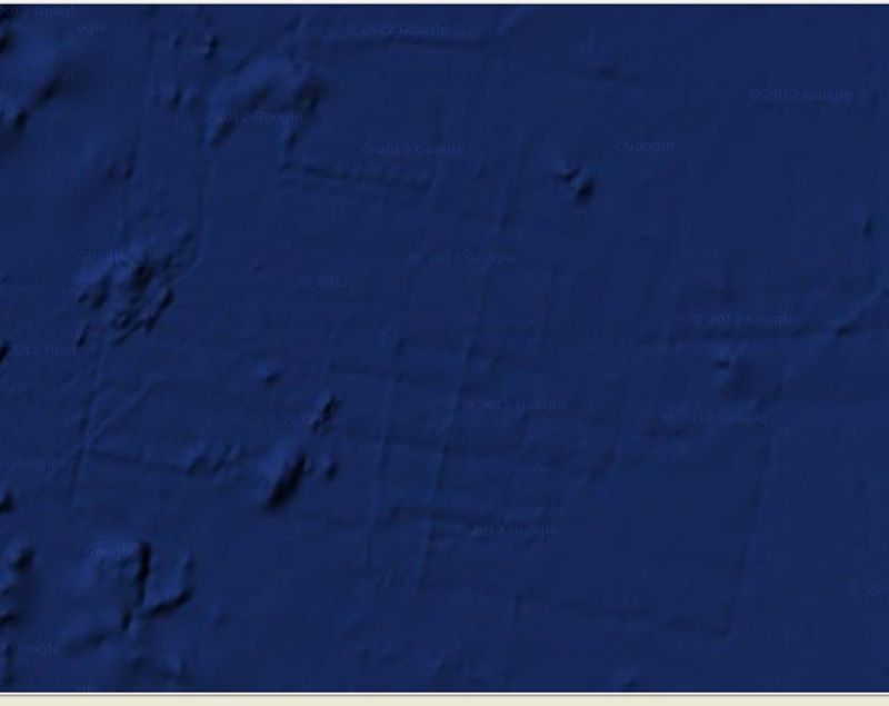
Modern tools of raster materials
processing allow the estimate many factors. I got the idea to scan the object for symmetry, though, I certainly understand that symmetrical cities with its narrow streets and relief are rare. But at that moment unexpected surprise. was waiting for me. Extinct town was symmetrical by more than 75%! Some individuals have own face less symmetrical than this order , probably at this moment I had just the same face expression. - says Sobolle. Superposition of turned in mirroring reflection of layer, gives the following result.
Next is a trick. To elect, and drawn the details. To remove unnecessary layers and colors. To reflect in the perspective.
The width of the artifact is 120 km. The
width of one the channel is 700-800 meters.The depth is 500 meters. The
probability of accuracy of graphical reconstruction is 65-70% (high
probability). Further, it becomes even more interesting. Quite recently, Google Earth has updated the image of the object, which were provided NASA and dated 2012. Data are presented as satellite images and after declaration of unnamed employee Google. Image of "Atlantis" has changed, the picture became more faded , but the lines still remained. This can only mean that the vessels were carrying sounders by the same path and they repeated the same clutters. 2009
How to relate to the fact of such an unusual artifact existence is a private matter. But at least this is a very interesting object, which probably is not radar error and which perhaps will present us much more surprises. Книга А. М. Кондратова "Атлантиды ищите на шельфе" Author: GeoLines |
 In early 2009 the
world had spread sensation - the legendary Atlantis is found, about
which Plato wrote. From the words of this ancient scholar, we learned
that this rich country located on the island was sunk after an
earthquake and floods around 9700 BC - about 12 000 years ago.
In early 2009 the
world had spread sensation - the legendary Atlantis is found, about
which Plato wrote. From the words of this ancient scholar, we learned
that this rich country located on the island was sunk after an
earthquake and floods around 9700 BC - about 12 000 years ago.


 Sensational! Tens of thousands of unknown geoglyphs have been found in the Sahara.
- In Moscow will bring a lot of the Antikythera mechanism.
- MOVING THE MEGALITHS – THE PROFANITY CONTINUES
- HEAVENLY CASTLE TAKEDA.
- RIDDLES PLATEAU RORAIMA.
- The Gospel of Judas
- At Nazca found beheading scene
LAST COMMENT
-
Все таки версия , что это все ... - пишет undefined в разделе ВПЕРЕД В ПРОШЛОЕ
-
Пентаграмма это суть эфиного п... - пишет undefined в разделе ВПЕРЕД В ПРОШЛОЕ
-
No problems. Just give a link ... - пишет undefined в разделе ONWARD TO THE PAST
-
Самый простой способ - это аму... - пишет undefined в разделе ВПЕРЕД В ПРОШЛОЕ
-
Документированный древний мето... - пишет undefined в разделе ВПЕРЕД В ПРОШЛОЕ
-
Документированный древний мето... - пишет undefined в разделе ВПЕРЕД В ПРОШЛОЕ
-
The Documented Ancient Constru... - пишет undefined в разделе ВПЕРЕД В ПРОШЛОЕ
-
Обычный выход расплава флюидол... - пишет undefined в разделе ВПЕРЕД В ПРОШЛОЕ
19.01.2019 Effective ways to improve health
Комментарии: 0
19.01.2019 Drink mineral water
Комментарии: 0
19.01.2019 Red fruits charge antioxidants
Комментарии: 0


