
|
Publications HISTORICAL GEODESYTHE PREHISTORIC ALIGNMENT OF WORLD WONDERS OTHER GREAT CIRCLE ALIGNMENTS OF ANCIENT SITES A SECOND EASTER ISLAND ALIGNMENT PART 10 ► A SECOND EASTER ISLAND ALIGNMENT ► A THIRD EASTER ISLAND ALIGNMENT ► A FOURTH EASTER ISLAND ALIGNMENT ► A SECOND GREAT PYRAMID ALIGNMENT ► A THIRD GREAT PYRAMID ALIGNMENT ►A SECOND PERSEOPOLIS ALIGNMENT ► A SECOND ANGKOR ALIGNMENT ► A SECOND NAZCA ALIGNMENT ► A SECOND MACHUPICCHU ALIGNMENT ► A SECOND CHACO CANYON ALIGNMENT ► A SECOND PALENQUE ALIGNMENT ►CONVERGENT ALIGNMENTS ►CONVERGENT ALIGNMENTS - PART II ►THE AVENUE OF THE DEAD ► THE GOLDEN SECTION - PART II ► IN SEARCH OF ATLANTIS - PART II © A SECOND EASTER ISLAND ALIGNMENT
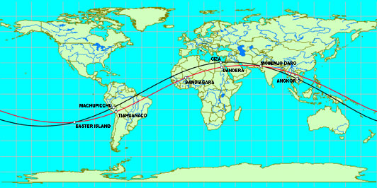
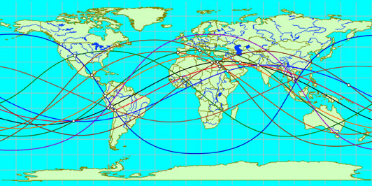
In Global Sacred Alignments, Terry Walsh diagrams several alignments of ancient sites on straight lines around the center of the earth, and mentions several others. He addresses the alignment of the Great Pyramid with Easter Island, Machupicchu and Persepolis, and he diagrams an alignment of Easter Island with Tiahuanaco, Luxor, Mohenjo Daro, Varanasi and Bandiagara, the ancient land of the Dogons. This second alignment also crosses over Dendera, Bodh Gaya and Mandalay. The total circumference of this second alignment is 24,892 miles. The great circle distance from Easter Island to Tiahuanaco is 2,703 miles, 10.8% of the total circumference. The distance from Tiahuanaco to Bandiagara is 4,930 miles, 19.8%. The distance from Bandiagara to Luxor is 2,473 miles, 9.9%. The distance from Luxor to Easter Island’s antipodal point in the Indus Valley near Ganweriwali is 2,363 miles, 9.5%. Because Easter Island, Machupicchu, the Great Pyramid, the Indus Valley and Angkor are also aligned at 10% intervals around the earth, there is a high coincidence of paired sites along these two alignments. In addition to the convergence of the two alignments at Easter Island and Mohenjo-Daro, Machupicchu is paired with Tiahuanaco and the Great Pyramid is paired with Luxor. If the pairing of these sites along these two alignments is not a coincidence, two good places to look for other ancient sites would be in the Sahara Desert, near the border between Mali and Mauritania, at 21° N, 7° 40' W, 2,488 miles southwest of the Great Pyramid, and in the shallow water of the South China Sea, just off the coast of Vietnam, at 18°43'N, 106°27'E, 2,488 miles southeast of Mohenjo-Daro. The axis points of this great circle are 62°03'N, 124°40'W and 62°03'S, 55°20'E. The great circle crosses the equator at 34°40'W and 145°20'E. The upper latitudes are 27°57'N at 55°20'E and 27°57'S at 124°40'W.
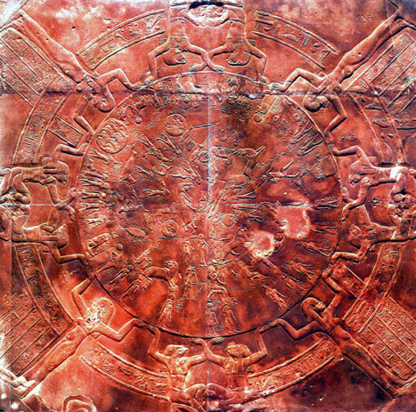
Above: The zodiac that was carved on the ceiling of the temple at Dendera.
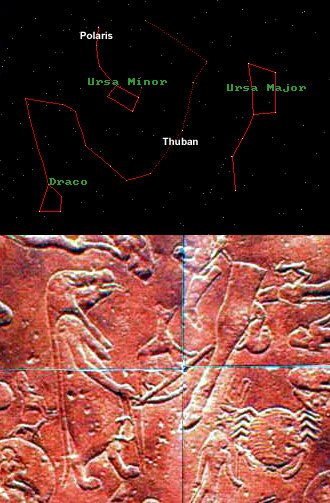
Below: Northern constellations and center of Dendera zodiac.
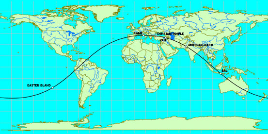
Another great circle alignment of sacred sites diagramed by Terry Walsh includes Easter Island, Fatima, Filitosa, Rome, Mohenjo Daro and Bali. Constantinople, Hattusas, Van and Mehrgarh are also on this alignment. The axis points of this great circle are 48°07'S, 15°23'E and 48°07'N, 164°37'W. The great circle crosses the equator at 105°23'E and 74°37'W. The upper latitudes are 41°53'N at 15°23'E and 41°53'S at 164°37'W.
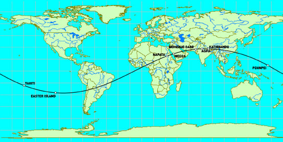
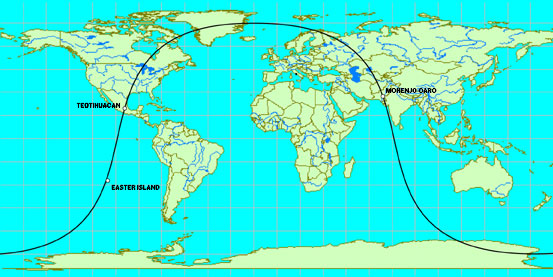
Easter Island is aligned with Napata at the base of Gebel Barkal mountain; Mecca; Mohenjo Daro; Agra; Kathmandu; Pohnpei; Tahiti and the coral ring islands of Bora Bora and Huahani.
The axis points of this great circle are 62°34'N, 98°30'W and 62°34'S, 81°30'E. The great circle crosses the equator at 8°30'W and 171°30'E. The upper latitudes are 17°26'S at 98°30'W and 17°26'N at 81°30'E.
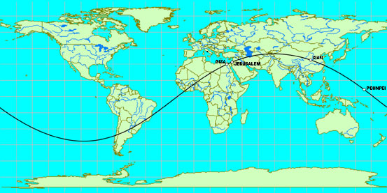
The Great Pyramid is aligned with the Temple Mount in Jerusalem; the Great Wall of China; the Chinese city of Xian, site of the terracotta soldiers, the unexcavated tomb of Qin Shi Huang, the first Emperor of China, and numerous other pyramids and burial mounds; and the underwater ruins of Nan Madol that surround Pohnpei Island. The axis points of this great circle are 50°40'N, 103°30'W and 50°40'S, 72°30'E. The great circle crosses the equator at 13°30'W and 162°30'E. The upper latitudes are 29°20'N at 72°30'E and 29°20'S at 103°30'W.
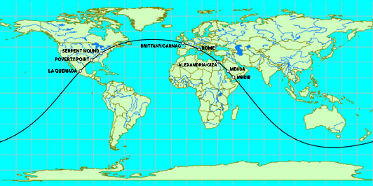
The Great Pyramid is aligned with La Quemada, Poverty Point, Serpent Mound, Brittany, Rome, Alexandria, Mecca and Marib.
The axis points of this great circle are 38°16'S, 31°44'W and 38°16'N, 148°16'E. The great circle crosses the equator at 121°44'W and 58°16'E. The upper latitudes are 51°44'N at 31°44'W and 51°44'S at 148°16'E.
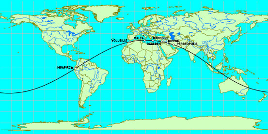
Persepolis is aligned with the ancient Sumarian/Babylonian/Assyrian center at Nippur; Baalbek and the ancient Phoenician city of Byblos; the ancient cities of Palaikastro and Knossos on the Island Of Crete; the Island of Malta; the North African site of ancient Roman construction at Volubilis; and the Incan and Pre-Incan fortress, temples and astronomical observatories at Ingapirca. The axis points of this great circle are 54°05'N, 165°20'W and 54°05'S, 14°40'E. The great circle crosses the equator at 75°20'W and 104°40'E. The upper latitudes are 35°55'S at 165°20'W and 35°55'N at 14°40'E.
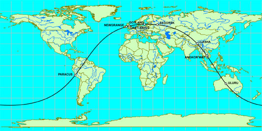
The Candelabra at Paracus is aligned with Newgrange, Castlerigg, Scandanavian stone shipsetting sites in Denmark, Sweeden and Gotland, Zagorsk, Llasha, Phimai, Angkor Wat and Uluru.
The axis points of this great circle are 32°40'N, 157°18'W and 32°40'S, 22°42'E . The great circle crosses the equator at 67°18'W and 112°42'E. The upper latitudes are 57°20'S at 157°18'W and 57°20'N at 22°42'E.
The antipodal locations of Nazca and Angkor are aligned with the very nearly antipodal locations of Hawaii and the ruins of Great Zimbabwe at Khami; the sanctuary at My Son along the coast of Vietnam; and the ruins of the ancient megalithic city of Tiahuanaco, on the shore of Lake Titicaca in South America.
The axis points of this great circle are 63°21'N, 15°W and 63°21'S, 165°E. The great circle crosses the equator at 105°W and 75°E. The upper latitudes are 26°39'S at 15°W and 26°39'N at 165°W.
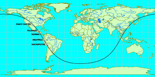
Machupicchu, Ollantaytambo, Saqsaywaman and Cusco are aligned with Ingapirca; Tazumal, Mixco Viejo, Bonampak, Palenque, and La Venta; Chaco Canyon and Mesa Verde.
This alignment also crosses over the source of the Amazon River; the mouth of the Parana River at Buenos Aires; the mouth of the Mekong River at Oc-Eo; the mouth of the Xi river at Macau; the mouth of the Yangtze River at Shanghai; and the mouth of the Rio Grande River at Matamoros. The axis points of this great circle are 31°50'S, 170°40'W and 31°50'N, 9°20'E. The great circle crosses the equator at 80°40'W and 99°20'E. The upper latitudes are 58°10'N at 170°40'W and 58°10'S at 9°20'E.
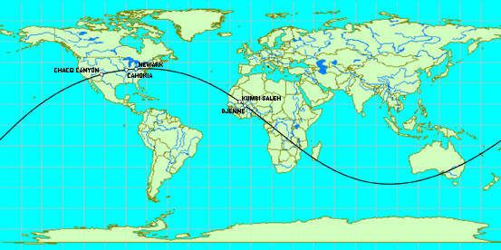
Chaco Canyon is aligned with the Cahokia Mounds; the Newark Earthworks; the ruins of ancient cities of Audaghast and Kumbi-Saleh in Mauritania; the sacred city of Djenne in Mali; and Meteor Crater, Arizona.
The axis points of this great circle are 49°53'S, 77°37'W and 49°53'N, 102°23'E. The great circle crosses the equator at 167°37'W and 12°23'E. The upper latitudes are 40°7'N at 77°37'W and 40°7'S at 102°23'E.
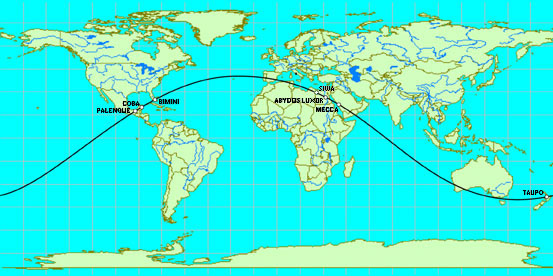
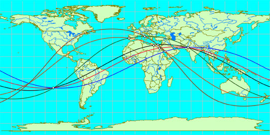
In Global Sacred Alignments, Terry Walsh diagrams the alignment of Palenque with Bimini, Fatima, Luxor, Mecca and the Tongariro World Heritage site in New Zealand. Abydos, the Valley of the Kings, Siwa, Lake Taupo and Coba are also on this alignment.
The axis points of this great circle are 49°09'S, 23°24'W and 49°09'N, 156°36'E. The great circle crosses the equator at 113°24'W and 66°36'E. The upper latitudes are 40°51'N at 23°24'W and 40°51'S at 156°36'E.
The distance along this great circle from Luxor to Palenque is 7690 miles. This is the same as the great cirlce distance from Giza to Nazca, creating a terrestrial triangle with the same angular dimensions as the great pyramid and creating the same φ relationship along this alignmnet. The distance along this great circle from Coba to Tongariro is 7464 miles. This is the same as the distance from Giza to Ollantaytambo, creating a terrestrial triangle with the same angular dimensions as the second pyramid at Giza and creating the same π and φ relationships along this alignment. Sites on convergent alignments include: Easter Island; Chaco Canyon; Palenque; Ingapirca; Nazca; Ollantaytambo; Tiahuanaco; Fatima; Bandiagara; Rome; Siwa; Giza; Luxor; Mecca; Perseopolis; Mohenjo-Daro; Angkor and Pohnpei.
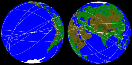
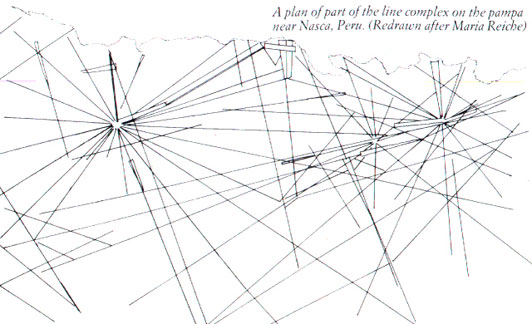
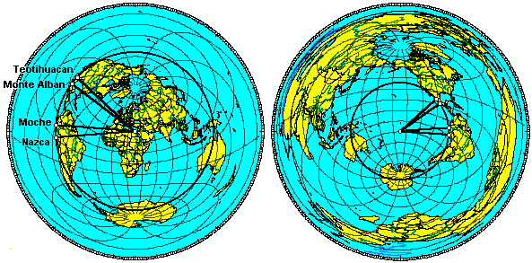
PART II Diagramed below are the three great circle alignments that include Mecca, and the four great circle alignments that include Easter Island and Mohenjo-Daro. Because one of the alignments includes all three sites, a total of six great circle alignments are shown. All of the intersections of these alignments that are above sea level are sites of historic or prehistoric world wonders. From left to right, the marked sites are Easter Island, Fatima, Rome, Siwa, Giza, Luxor, Mecca and Mohenjo-Daro. The largest pyramid complex in the Americas is located Northeast of Mexico City, at Teotihaucan. The entire ancient city was built on a geometric grid anchored by a central avenue that begins at the Pyramid of the Moon. This avenue, also known as the Way of the Dead, points 15.5 West of due South, and 15.5 degrees East of due North. Extending the alignment of the Way of the Dead to the South, it comes very close to crossing directly over Easter Island. Although Easter Island is antipodal to the Indus Valley, it is more nearly antipodal to the unexcavated city of Ganweriwali than to Mohenjo Daro. Extending the alignment of the Way of the Dead to the North, over the polar regions and back down through Eurasia, it crosses directly over Mohenjo-Daro. PART II The Great Pyramid is in the center of the equidistant azimuthal projection above left, and the circle is 7,685 miles away. In addition to Nazca and Teotihuacan, several other major ancient sites in the Americas are very close to the alignment of this circle, including Tula and Cholula in the Valley of Mexico; Monte Alban and Mitla in Oaxaca; and Tucume, Chan Chan, Moche, Sechin, Caral, Marcahuasi, Pachacamac and Tambo Colorado along coastal Peru. This same circle is projected above right, from the perspective of the other axis point for this circle (the Great Pyramid's antipodal point in the South Pacific Ocean) and from there, the circle is 4,750 miles away. The ratio between the distance from every one of these sites to the Great Pyramid, and from every one of these sites to the antipodal point of the Great Pyramid, approximates φ within a margin of error of less than two tenths of one percent: 7,685 miles/4,750 miles = 1.618 (φ)
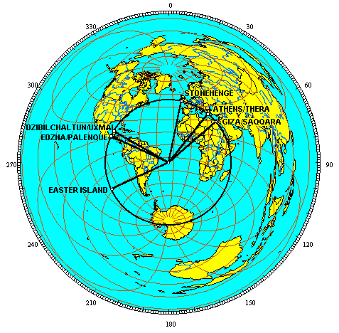
PART II A circle drawn around 20°55'S 26°10'W with a great circle radius of 5,180 miles crosses over the Great Pyramid, Easter Island, Palenque, Dzibilchaltun, Stonehenge, the Acropolis, Thera and Palaikastro. The distance from the North Pole to 15° north latitude is also 5,180 miles. Thus, the circumference of this circle is the same as the circumference of the 15th parallels. Northwest of the Acropolis, Delphi and Dodona are close to the circle. Northwest of the Great Pyramid, the ancient capitals of Alexandria and Sais in Egypt are close to the circle. Several pyramids and other sites of ancient construction, including Saqqara, are south-south-east of the Great Pyramid and on or near this circle. A number of Mayan and Olmec sites between Palenque and Dzibilchitun on the Yucatan Peninsula are also close to this circle, including Uxmal and Edzna.
|

 Sensational! Tens of thousands of unknown geoglyphs have been found in the Sahara.
- In Moscow will bring a lot of the Antikythera mechanism.
- MOVING THE MEGALITHS – THE PROFANITY CONTINUES
- HEAVENLY CASTLE TAKEDA.
- RIDDLES PLATEAU RORAIMA.
- The Gospel of Judas
- At Nazca found beheading scene
LAST COMMENT
-
Все таки версия , что это все ... - пишет undefined в разделе ВПЕРЕД В ПРОШЛОЕ
-
Пентаграмма это суть эфиного п... - пишет undefined в разделе ВПЕРЕД В ПРОШЛОЕ
-
No problems. Just give a link ... - пишет undefined в разделе ONWARD TO THE PAST
-
Самый простой способ - это аму... - пишет undefined в разделе ВПЕРЕД В ПРОШЛОЕ
-
Документированный древний мето... - пишет undefined в разделе ВПЕРЕД В ПРОШЛОЕ
-
Документированный древний мето... - пишет undefined в разделе ВПЕРЕД В ПРОШЛОЕ
-
The Documented Ancient Constru... - пишет undefined в разделе ВПЕРЕД В ПРОШЛОЕ
-
Обычный выход расплава флюидол... - пишет undefined в разделе ВПЕРЕД В ПРОШЛОЕ
19.01.2019 Effective ways to improve health
Комментарии: 0
19.01.2019 Drink mineral water
Комментарии: 0
19.01.2019 Red fruits charge antioxidants
Комментарии: 0


