
|
News News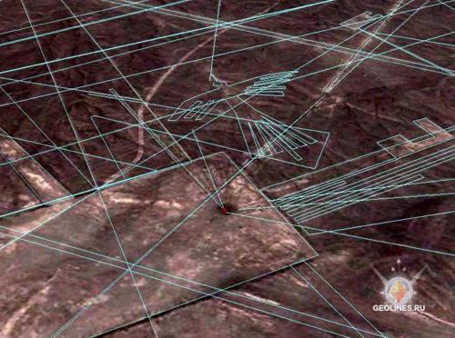 File "NASKA LINES ", extended on subscription is updated. It is added more than 200 geometrical figures and lines. File "NASKA LINES", extended on subscription is updated. It is added more than 200 "arrows" and lines. The file has expansion (kmz.), it opens only in a program Google Earth. For more convenient viewing of Nazca geogliphs, it is recommended to disconnect a layer, Panoramio because big quantity of the placed photos will stir. Figures are put with the maximum accuracy and repeat contours of Nazca drawings, existing in reality. At geogliph decoding space pictures Google were used.
|
 Sensational! Tens of thousands of unknown geoglyphs have been found in the Sahara.
- In Moscow will bring a lot of the Antikythera mechanism.
- MOVING THE MEGALITHS – THE PROFANITY CONTINUES
- HEAVENLY CASTLE TAKEDA.
- RIDDLES PLATEAU RORAIMA.
- The Gospel of Judas
- At Nazca found beheading scene
LAST COMMENT
-
Все таки версия , что это все ... - пишет undefined в разделе ВПЕРЕД В ПРОШЛОЕ
-
Пентаграмма это суть эфиного п... - пишет undefined в разделе ВПЕРЕД В ПРОШЛОЕ
-
No problems. Just give a link ... - пишет undefined в разделе ONWARD TO THE PAST
-
Самый простой способ - это аму... - пишет undefined в разделе ВПЕРЕД В ПРОШЛОЕ
-
Документированный древний мето... - пишет undefined в разделе ВПЕРЕД В ПРОШЛОЕ
-
Документированный древний мето... - пишет undefined в разделе ВПЕРЕД В ПРОШЛОЕ
-
The Documented Ancient Constru... - пишет undefined в разделе ВПЕРЕД В ПРОШЛОЕ
-
Обычный выход расплава флюидол... - пишет undefined в разделе ВПЕРЕД В ПРОШЛОЕ
19.01.2019 Effective ways to improve health
Комментарии: 0
19.01.2019 Drink mineral water
Комментарии: 0
19.01.2019 Red fruits charge antioxidants
Комментарии: 0


