
|
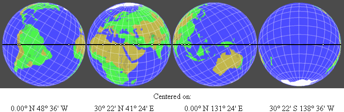
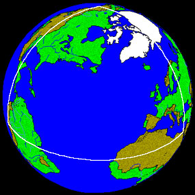
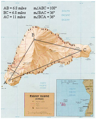
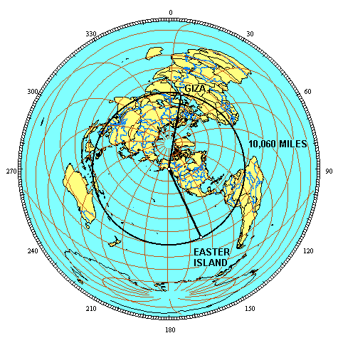
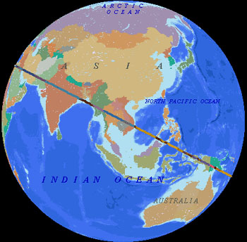
Publications HISTORICAL GEODESY@ JIM ALISON ► PART II ► PART III ► PART IV ► PART V ► PART VI ► PART VII ► PART VIII ► PART IX ► PART X ► PART XI ► PART XII ► LINKS ♦ A NEW LOOK AT AN OLD DESIGN THE PREHISTORIC ALIGNMENT OF WORLD WONDERS THE GREAT CIRCLE PART I Great circles are straight lines that go all the way around the center of the earth. The equator is a great circle. Meridians of longitude that cross over the north and south poles are also great circles. For every location on a great circle, it's antipodal location is also on the circle. Other than the equator itself, any great circle crosses the equator at two antipodal locations, 180° apart. Other than the equator and meridians of longitude that run due north and south, any great circle reaches it's maximum latitudes at two locations that are 90° of longitude east and west of the two locations where the great circle crosses the equator. Easter Island, Nazca, Ollantaytambo, Paratoari, Tassili n'Ajjer and Giza are all aligned on a single great circle. Additional ancient sites that are located within one tenth of one degree of this great circle include Petra; Perseopolis; Khajuraho; Pyay, Sukothai and Anatom Island. Near Ollantaytambo, Machupicchu and Cuzco are within one quarter of a degree. The Oracle at Siwa in the western Egyptian desert is within one quarter of a degree. In the Indus Valley, Mohenjo Daro and Ganweriwala are within one quarter of a degree. The ancient Sumerian city of Ur and Angkor temples in Cambodia and Thailand are within one degree of the great circle. The Angkor temple at Preah Vihear is within one quarter of a degree. This circle crosses over the source and the mouth of the Amazon, the dividing line between upper and lower Egypt, the mouth of the Tigris-Euphrates, the Indus River and the Bay of Bengal near the mouth of the Ganges. The circle also crosses over a number of areas of the world that are largely unexplored, including the Sahara Desert, the Brazilian Rainforest, the highlands of New Guinea, and underwater areas of the North Atlantic Ocean, the South Pacific Ocean and the South China Sea. The alignment of these sites is easily observable on a globe of the earth with a horizon ring. Aligning any two of these sites on the horizon ring will align all of these sites on the ring. 3-D world atlas software programs will also draw this great circle around the earth. The four images below are centered on the two locations where the great circle crosses the equator and the two locations where the great circle reaches it's maximum latitudes. The circle crosses over the equator at 48° 36' west longitude and 131° 24' east longitude. The maximum latitude of the circle is 30° 22' north latitude at 41° 24' east longitude and 30° 22' south latitude at 138° 36' west longitude.
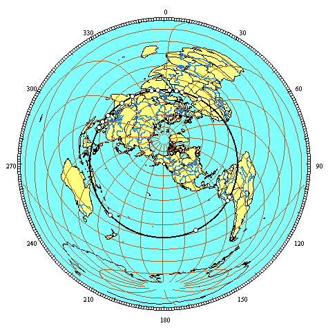
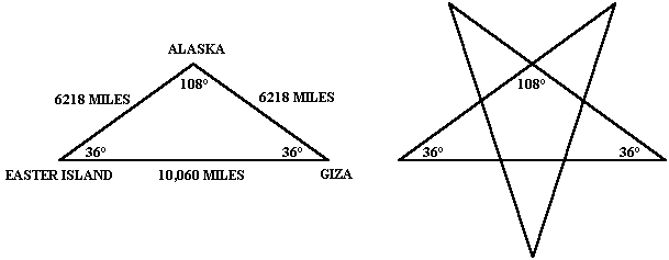
All great circles have two antipodal axis points. The two axis points for the equator are the north and south poles. Every point along the equator is equally distant at 90°, or one quarter of the circumference of the earth, from the north and south poles. For any great circle, the distance from the axis points to any point along the circle is one quarter of the circumference of the earth. For any great circle other than the equator, the longitude of the axis points are 90° east and west of the two points where the great circle crosses the equator. Great circles that run due north-south along meridians of longitude have their axis points on the equator, 90° of longitude east and west of the points where the meridian circle crosses the equator and 90° of latitude from the poles where meridian circles reach their maximum latitudes. The distance from the axis points to any point along a meridian circle is one quarter of the circumference of the earth, but 90° of longitude from the axis point to the point where the meridian circle crosses the equator is 6,225 miles, while 90° of latitude from the axis point to the maximum latitude of the meridian circle at the poles is 6,215 miles. This is because the polar circumference of the earth is 24,860 miles, while the equatorial circumference is 24,901 miles, due to the bulge of the earth at the equator and the flattening of the earth at the poles. Our modern system of calculating degrees of latitude from the equator to the poles is based on the north-south angular change along the surface of the earth. As a result, degrees of latitude are slightly longer at the poles, where the earth is flatter, and slightly shorter at the bulge of the equator. For great circles other than the equator and other than meridian circles, the north-south distance from the axis points to the great circle crosses over the pole in one direction, while it crosses over the equator in the other direction. As a result, the latitude of the axis points must be adjusted slightly to compensate for the longer distance of degrees of latitude at the poles and the shorter distance of degrees of latitude at the equator. The two axis points for the great circle illustrated above are located at 59° 53' north latitude and 138° 36' west longitude and at 59° 53' south latitude and 41° 24' east longitude. The southern axis point is in deep water approximately 500 miles from the coast of Antarctica. The northern axis point is in the northwestern corner of Canadian British Columbia on a glaciated ridge line approximately 6,500 feet above sea level. The circumference of this great circle is 24,892 miles. This is slightly less than the equatorial circumference of the earth, but closer to the equatorial than the polar circumference because the maximum latitude of the great circle is closer to the equator than the poles, and because most of the shortening of the polar circumference is due to the flattening of the earth near the poles. The chart below lists the distance of each site from the great circle and the distance of each site from the northern axis point. There are slight variations in the distance from the axis point to the great circle depending on whether the route from the axis point to different locations along the great circle crosses over the equator or polar regions. The mean distance from the axis point to the great circle is 6,218 miles.
The sites listed above are shown clockwise from Giza on the equal azimuthal projection below. The projection is centered on the axis point in southeastern Alaska. Distances to any location from the center of an equal azimuthal projection are equally scaled. Since all of the sites on the great circle alignment are equally distant from the axis point at one quarter of the circumference of the earth, the alignment forms a perfect circle halfway between the center and the outer edge of the projection.
PART II The Greek letter phi (φ) signifies the golden section, also known as the divine proportion of 1.618 to one. The mathematical formula for φ is the square root of five plus one, divided by two. If a line is divided with the ratio of φ between the longer segment and the shorter segment, the ratio between the whole line and the longer segment is also φ. Given a length of one for the shorter segment, the length of the longer segment is φ and the length of the entire segment is φ plus one. φ plus one is also equal to φ²: 1.618 + 1 = 2.618 and Given a length of one for the longer segment, the shorter segment is 1/φ (.618) and the length of the entire segment is φ. 1/φ is also equal to φ minus one: 1 ÷ 1.618 = .618 and There is also an extremely close mathematical relationship between φ and π expressed as φ² x 6 = π x 5 (2.618 times 6, divided by 5, equals 3.1416). There is an ongoing dispute about whether or not there was an ancient awareness of φ and π. In the ancient world, φ existed naturally in the proportions and growth rates of plant and animal species, as well as spirals ranging from microscopic to flowering plants and seashells to the spiral arms of the galaxy. The π ratio between the diameter and the circumference of a circle also existed naturally in the ancient world. It has also been shown that φ and π existed in many man-made ancient buildings, including the great pyramid of Giza.
Angkor Wat is 4,745 miles from the Great Pyramid and the Great Pyramid is 7,677 miles from Nazca. This is a precise expression of φ:
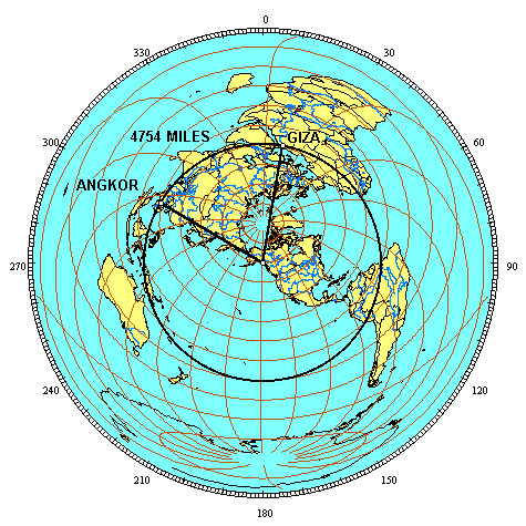
Ninety miles northeast of Angkor Wat are the Angkor temples at Prassat Preah Vihear. Preah Vihear is 4754 miles from the Great Pyramid. The line of ancient sites crosses over the Great Pyramid and Angkor Vihear.
The relationship between the distances from Angkor Vihear to the Great Pyramid and from the Great Pyramid to the Nazcan Hummingbird is also a precise expression of φ: 4,754 x 1.618 = 7,692 Because the Hummingbird and Angkor Vihear are antipodal sites, with a distance between them of one-half of the circumference of the earth, two Golden Section relationships between these three sites are shown by the circumference of the earth along the line of ancient sites:
4,754 x 1.618 = 7,692 4,754 + 7,692 = 12,446, and 7,692 x 1.618 = 12,446
The line of ancient sites is a line, from the perspective of the first illustration in Part One, and it is a circle, from the perspective of the azimuthal projection above. The line and the circle are found in the greek letter φ and the number 10. Zero and one are also the first two numbers and the only two numbers in the binary code. The φ relationships between these sites are reflected repeatedly in the first 500 Fibonacci numbers. The first three prime numbers, 2, 3 and 5, approximate the intervals along the circumference of 20%, 30% and 50%, between these three sites. This same percentage of the circumference relationship, accurate to three digits, is found in Fibonacci numbers 137-139:
The next prime Fibonacci number after #137 is #359. The distances between these sites, in miles, is reflected by Fibocacci numbers 359-361, accurately to five digits:
See Also: Golden Section Alignment of Ankgor, Nazca and San Francisco PART III
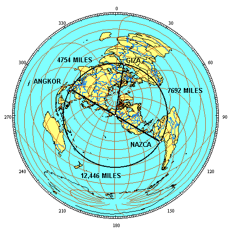
The 3D global image above is centered in the middle of the terrestrial triangle. As a result, all three of the great circle segments are curved. The equal azimuthal projection below is centered on the axis point. As a result, the great circle segments from the axis point to Giza and to Nazca are straight lines. 7692 miles is 30.9% of the circumference of the great circle (7692/24,892 = .309) or 111.245° along the great circle (.309 x 360 = 111.245 ). The azimuth of the great circle segment from the axis point to Giza is 9° and the azimuth of the great circle segment from the axis point to Nazca is 120°, showing that the angle at the axis point is also 111°. The distance from the axis point to Giza and to Nazca is one quarter of the circumference of the earth, or 90°. Since the great circle segments from the axis point are perpendicular to the great circle itself, the angles at Giza and Nazca are also 90°.
A simple spherical trigonometry formula converts the 90° - 90° - 111° spherical triangle to an equivalent flat surface triangle. The angle opposite the baselength is divided by two (111.235°/2 = 55.6225°), and then divided by the angle adjacent to the baselength (55.6225°/90° = .618). The φ reciprocal is .618 (1/φ). Applying the inverted cosine function to .618 gives 51.83° for the flat surface equivalents of the 90° spherical angles at Nazca and Giza. These are the same as the angular dimensions of the great pyramid. Alternatively, the two great circle segments from the axis point to Nazca and from the axis point to Giza are each 25% of the circumference of the earth while the great circle segment from Nazca to Giza is 30.9% of the circumference of the earth. The two great circle segments from the axis point to Nazca and to Giza add up to 50% of the circumference of the earth and 50/30.9 = 1.618, also demonstrating that these three great circle segments form a triangle equivalent to the crossection of the great pyramid, with the same φ proportion:
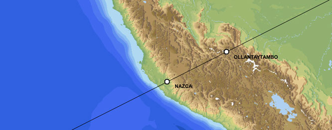
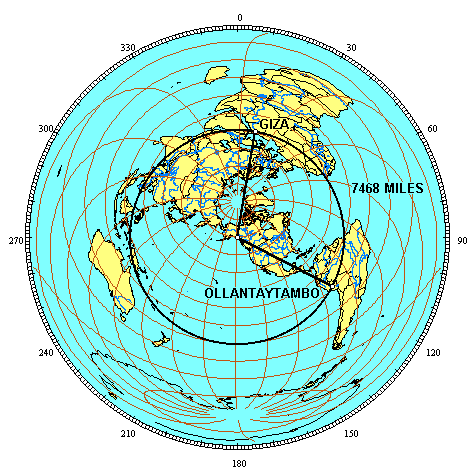
Given side lengths of 6218 miles from the axis point to Giza and Nazca, the distance from Giza to Nazca would have to be 7686 miles for the φ ratio to be exact, based on an ellipsoidal earth model. The main group of lines and figures at Nazca that is included as a UNESCO world heritage site is approximately 25 miles E-W and 4 miles N-S. The distance of 7692 miles from Giza along the great circle and the distance of 7686 miles from Giza along the great circle both fall within the main part of the Nazca lines and figures that are designated by UNESCO for protection as a world heritage site, so in the case of Nazca the φ relationship is present with either a round earth assumption or an ellipsoidal model. PART IV Ollantaytambo is 7468 miles from Giza. 30% of the circumference of the great circle is 7468 miles (24,892 x .3 = 7468). Ollantaytambo is precisely 30%, or 108° along the great circle, from Giza. The azimuth from the axis point to Giza is 9° and the azimuth from the axis point to Ollantaytambo is 117°, also showing that the terrestrial angle at the axis point is 108°. The angles at Ollantaytambo and at Giza are 90° and the distance from the axis point to Ollantaytambo and to Giza is 90° or 25% of the circumference of the earth.
φ² x 6/5 = π (2.618 x 6/5 = 3.1416). This terrestrial triangle (and the second pyramid at Giza) have a ratio between the baselength and the sidelength of 3.1416 : 2.618. PART V Angkor Preah Vihear is 4754 miles from Giza. This is 19.1% of the great circle circumference, or 68.754° (19.1% times π equals 60.00% and 68.754° times π equals 216.00°). The two great circle segments from the axis point to Giza and to Angkor Vihear are each 90°, or 180° combined. 180°/68.754° = 2.618. The ratio between both sides of this terrestrial triangle and the baselength of the triangle is 2.618 to one.
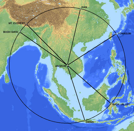
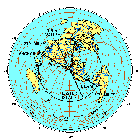
The image below is centered on Angkor Wat and the circle is 1,466.6 miles away. East of Xian, the Longmen caves are close to this alignment. Just south of Dieng, Borobudur and Prambanan are also close to this alignment.
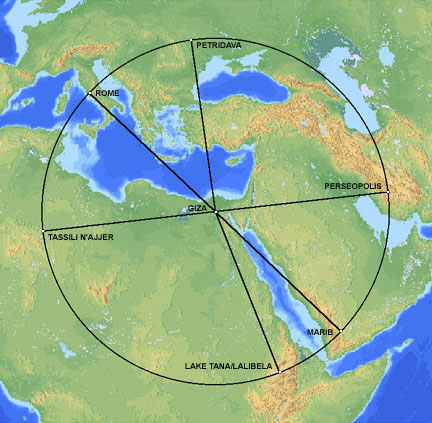
In addition to crossing over the center of the alignments around Angkor and around Giza, the Indus Valley alignment also crosses over the perimeter of the other two alignments at significant locations (Lake Tana and Xian). The radius of the Angkor alignment times 1.618 equals the radius of the Indus Valley alignment and the radius of the Indus Valley alignment times .618 equals the radius of the Angkor alignment, demonstrating the φ relationship between the two alignments:
PART VI
The φ ratio between the distance from Easter to Giza and the distances from the axis point to Easter and Giza is also shown by these measures in kilometers. One quarter of the circumference of the earth is 10,000 kilometers. The distance from Easter to Giza is 16,180 kilometers, expressing the φ ratio of 1.618 : 1.
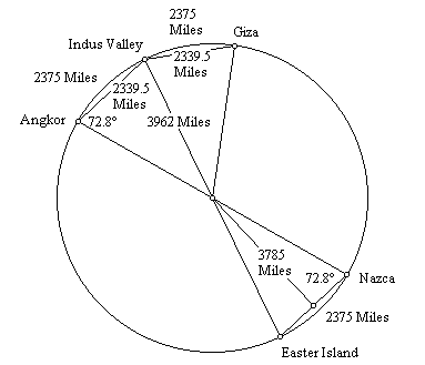
PART VII The great circle distance from Easter Island to Nazca is 2375 miles, or 9.54% of the great circle (2375/24,892 = 09.54) or 34.344° (.0954 x 360 = 34.344°). This also gives 34.344° for the angle between the two sites at the center of the earth. One half of this angle is 17.172°.The straight line distance between the two sites is equal to the sine of one half of their angle at the center of the earth times the diameter of the earth. The sine of 17.172° is .29524. The diameter of the earth (7924 miles) times .29524 gives 2339.5 miles for the straight line (through the earth) distance from Easter to Nazca. The height of a triangle with sides of 3962 miles and a baselength of 2339.5 miles is 3785 miles. The baselength of the triangle times φ is equal to the height of the triangle (2339.5 x 1.618 = 3785). The center of the earth, Angkor and Easter’s antipodal point in the Indus Valley forms this same φ triangle, as does the triangle formed by the center of the earth, the Indus Valley and Giza.
440 cubits ÷ 2 = 220 cubits 220 cubits x 1.618 = 356 cubits The ratio of the base to the slant height of the Great Pyramid is exactly two times the ratio of the base to the height of the throught the earth triangles shown above. Just south of Giza, the step pyramid at Saqqara is believed to have been the first stone pyramid built in Egypt.
The straight line distance, through the Earth, from Angkor Wat to Easter (7,574 miles), plus the straight line distance from Easter to Macchupicchu (2,522 miles), equals the great circle distance from Angkor Wat to Easter (10,096 miles). The straight line distance from the Great Pyramid to Easter (7,566 miles) is three times the straight line distance from Easter to Machupicchu (2,522 miles). The straight line distance from Easter to its antipodal point in the Indus Valley (7,924 miles), which is also the diameter of the Earth, is 3.1416 times the straight line distance from Easter to Machupicchu (2,522 miles), a precise expression of π. Since the circumference of the Earth is also 3.1416 times the diameter of the Earth, the straight line distance from Easter to Machupicchu times π² equals the circumference of the Earth. PART VIII As the Earth rotates on it’s axis, the Equator remains aligned, but the line of ancient sites describes a sine wave as a result of it’s tilt relative to the Equator. The line of the ecliptic may be observed describing a similar wave by spinning a globe that has a line of the ecliptic. The wave may also be visualized by drawing the line of ancient sites on a flat projection of the Earth. The wavelength is equal to the circumference of the Earth. The amplitude of this wave, measured from the middle of the wave (the equator), is 30° of latitude. Recall that the 30th parallels are ½ of the height of each hemisphere, or ½ of the radius of the Earth. Since the height of the wave is equal to ½ of the Earth’s radius, the ratio between the wavelength and it’s amplitude is 4π. Measuring the amplitude from the top of the wavelength to the bottom (from 30° N to 30° S), the amplitude is equal to the radius of the Earth, and the ratio between the wavelength and the amplitude is 2π. PART IX
Machupicchu and the Great Pyramid are equally distant from the Cape Verde Islands. Easter Island and the Indus Valley are also equally distant from Cape Verde. When the Cape Verde Islands were rediscovered by European mariners in 1460 they were found to be uninhabited. However, islands in this location are found on earlier maps and described as inhabited in ancient times. The Mecia de Viladestes map of 1413 shows islands in the location of Cape Verde labeled Gades. The information in this map is thought to have come from Roman sources dating back to the first century AD. The discoveries of the world from their first originall unto the yeere of our Lord 1555, written by Antonio Galvao in 1563, lists the ancient names for the Cape Verde Islands as the Dorcades, Hesperides and the Gorgades. A 1587 map by Richard Hakluyt also labels the Cape Verde Islands as the Gorgades and the Hesperides. According to Plato, there was a mountainous region north of the city of Atlantis. One possible location for Atlantis is in the Atlantic Ocean, just south of the Cape Verde Islands.
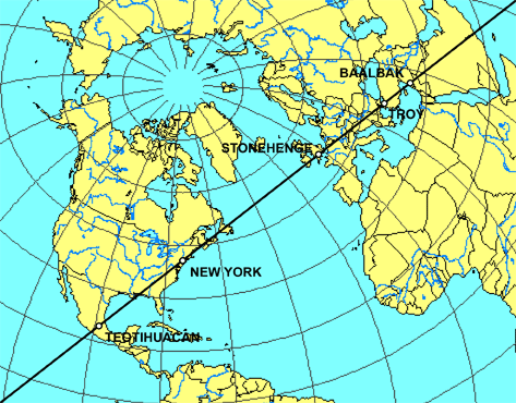
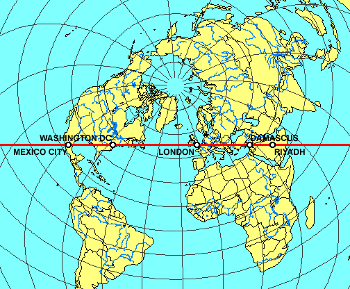
OTHER GREAT CIRCLE ALIGNMENTS OF ANCIENT SITES PART X • A SECOND EASTER ISLAND ALIGNMENT also includes Tiahuanaco, Bandiagara Dendera, Luxor, Mohenjo-Daro, Varanasi, Bodh Gaya and Mandalay. • A THIRD EASTER ISLAND ALIGNMENT also includes Fatima, Filitosa, Rome, Constantinople, Hattusas, Van, Mehrgarh, Mohenjo-Daro and Bali. • A FOURTH EASTER ISLAND ALIGNMENT also includes Napata, Mecca, Mohenjo-Daro, Mohenjo-Daro, Agra, Kathmandu, Pohnpei and Tahiti. • A SECOND GREAT PYRAMID ALIGNMENT also includes Jerusalem, Xian, and Pohnpei. • A THIRD GREAT PYRAMID ALIGNMENT also includes La Quemada, Poverty Point, Serpent Mound, Brittany, Rome, Alexandria, Mecca and Marib. • A SECOND PERSEOPOLIS ALIGNMENT also includes Nippur, Baalbek, Byblos, Palaikastro, Knossos, Malta, Timg alt="JIM ALISON THE PREHISTORIC ALIGNMENT OF WORLD WONDERS"ad, Volubilis and Ingapirca. • A SECOND ANGKOR ALIGNMENT also includes Paracus, Newgrange, Castlerigg, Gotland, Zagorsk, Llasha, Phimai and Uluru. • A SECOND NAZCA ALIGNMENT also includes Tiahuanaco, Khami, Great Zimbabwe, Angkor Wat, Preah Vihear, My Son and Hawaii. • A SECOND MACHUPICCHU ALIGNMENT also includes Ollantaytambo, Saqsaywaman, Cusco, Ingapirca, Tazumal, Mixco Viejo, Bonampak, Palenque, La Venta, Mesa Verde and Chaco Canyon. • A SECOND CHACO CANYON ALIGNMENT also includes Cahokia Mounds, the Newark Earthworks, Audaghast, Koumbi Saleh Djenne, and Meteor Crater, Arizona. • A SECOND PALENQUE ALIGNMENT also includes Coba, Bimini, Fatima, Abydos, the Valley of the Kings, Luxor, Mecca and Taupo. • CONVERGENT ALIGNMENTS include Easter Island, Chaco Canyon, Palenque, Ingapirca, Nazca, Ollantaytambo, Bandiagara, Fatima, Rome, Siwa, Giza, Luxor, Mecca, Perseopolis, Mohenjo-Daro, Angkor and Pohnpei. PART XI The old urban centers on the Eastern Seaboard of the U.S are in nearly perfect alignment. The image below is a cropped 3D projection centered on New York City.
See Also: WASHINGTON D.C. GEOMETRY PART XII ► VectorGlobe - 3-D world atlas with topographical, bathymetric and political features, and a large database of sites. ► GcmWin - equal azimuthal global projection program that can be centered on any selected coordinates. ► Global Gazetteer - exact coordinates of over 2.8 million sites worldwide. ► NASDA/MITI - satellite images of the world's rainforests. ► Great Circle Calculator - great circle distances from cities or lat-long coordinates. ► Starpathdemos - precise measures of degrees of latitude and longitude at any given latitude. Becker/Hagens • Jon Bodsworth • Jim Bowles • Andrew Collins • Antonio de la Cova • Rand Flem-Ath • Martin Gray • Graham Hancock • James Jacobs • Charles Johnson • Andis Kaulins • CarrieKozikowski • Jean-Pierre Lacroix • Simon Miles • CarlMunck • Sacred texts • Dan Shaw • Alex Sokolowski • Livio Stecchini • Terry Walsh • John Anthony West • World Heritage BACK to Publications /p /span
undefined 10.04.2024 02:41:07
So, since this was made, Atlantis was found in Africa. The entire site was washed west when earth flipped 12,900 years ago and the proof is everywhere. Giant salt lakes that dried up. A giant lava flow partially washed out after the 'dated' volcano erupted. Giant cinder cones left streaks of iron oxide westward across the landscape. The remains of the great city Atlantis with all it's canals now shows only remains of it's concentric circle walls poking out of the African desert, and is known today as the Eye of the Sahara.
Ответить
|
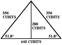


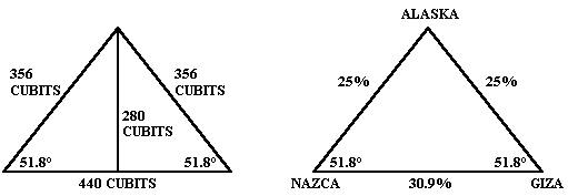
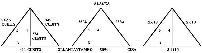

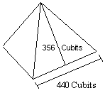 The length of the base of each face of the Great Pyramid is 440 cubits. The slant height of each face is 356 cubits. One half of the length of the base times φ equals the slant height of the Great Pyramid:
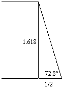
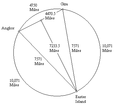
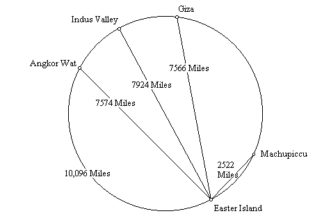
 Image © Cosmi 3-D World Atlas
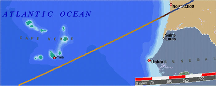

 Sensational! Tens of thousands of unknown geoglyphs have been found in the Sahara.
- In Moscow will bring a lot of the Antikythera mechanism.
- MOVING THE MEGALITHS – THE PROFANITY CONTINUES
- HEAVENLY CASTLE TAKEDA.
- RIDDLES PLATEAU RORAIMA.
- The Gospel of Judas
- At Nazca found beheading scene
LAST COMMENT
-
Все таки версия , что это все ... - пишет undefined в разделе ВПЕРЕД В ПРОШЛОЕ
-
Пентаграмма это суть эфиного п... - пишет undefined в разделе ВПЕРЕД В ПРОШЛОЕ
-
No problems. Just give a link ... - пишет undefined в разделе ONWARD TO THE PAST
-
Самый простой способ - это аму... - пишет undefined в разделе ВПЕРЕД В ПРОШЛОЕ
-
Документированный древний мето... - пишет undefined в разделе ВПЕРЕД В ПРОШЛОЕ
-
Документированный древний мето... - пишет undefined в разделе ВПЕРЕД В ПРОШЛОЕ
-
The Documented Ancient Constru... - пишет undefined в разделе ВПЕРЕД В ПРОШЛОЕ
-
Обычный выход расплава флюидол... - пишет undefined в разделе ВПЕРЕД В ПРОШЛОЕ
19.01.2019 Effective ways to improve health
Комментарии: 0
19.01.2019 Drink mineral water
Комментарии: 0
19.01.2019 Red fruits charge antioxidants
Комментарии: 0


