|
1
ONWARD TO THE PAST
 SYSTEM OF ANCIENT MONUMENTAL CONSTRUCTIONS AND NAZCA LINES. SYSTEM OF ANCIENT MONUMENTAL CONSTRUCTIONS AND NAZCA LINES.
Thesis presentation.
|
|
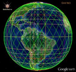
The most of famous ancient constructions, such as Great Pyramid, Stonehenge, Easter Island, Teotihuacan, Tiwanaku, Baalbek, and many others can be combined into a single system built according to certain mathematical principles. The whole system by means of lines geometric figures and the centers displayed graphically on Nazca as geoglyphs, which are flight map.
|
|
The system of ancient monumental constructions (SAMC) consists of several subsystems, like nested one to other.
|
|
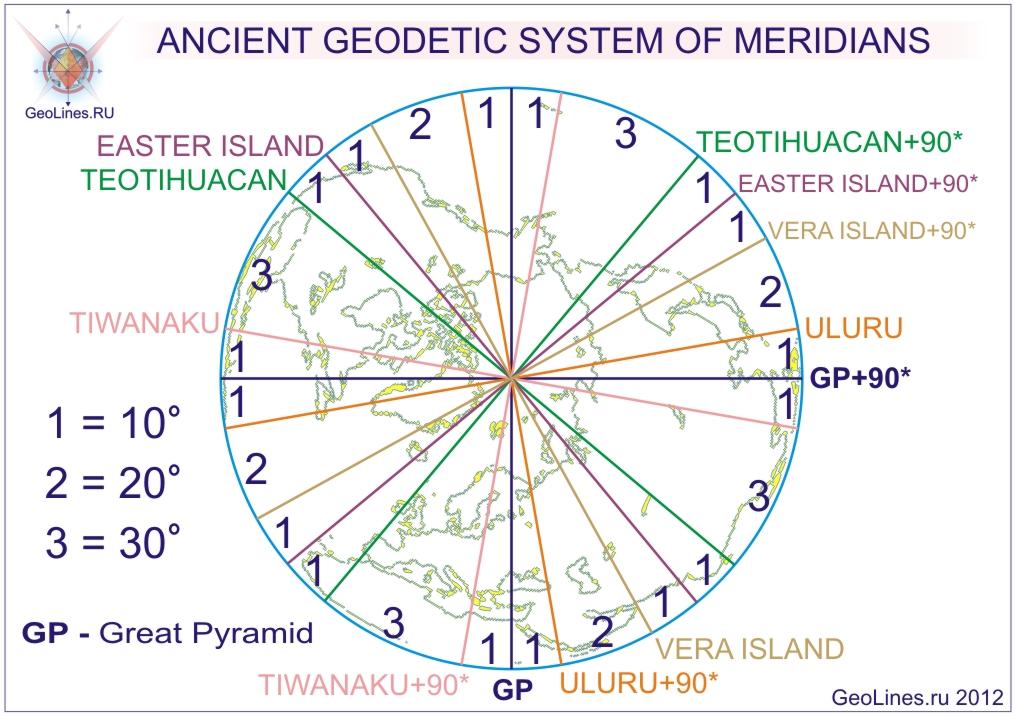
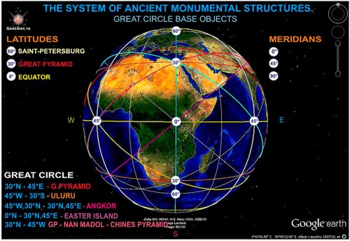
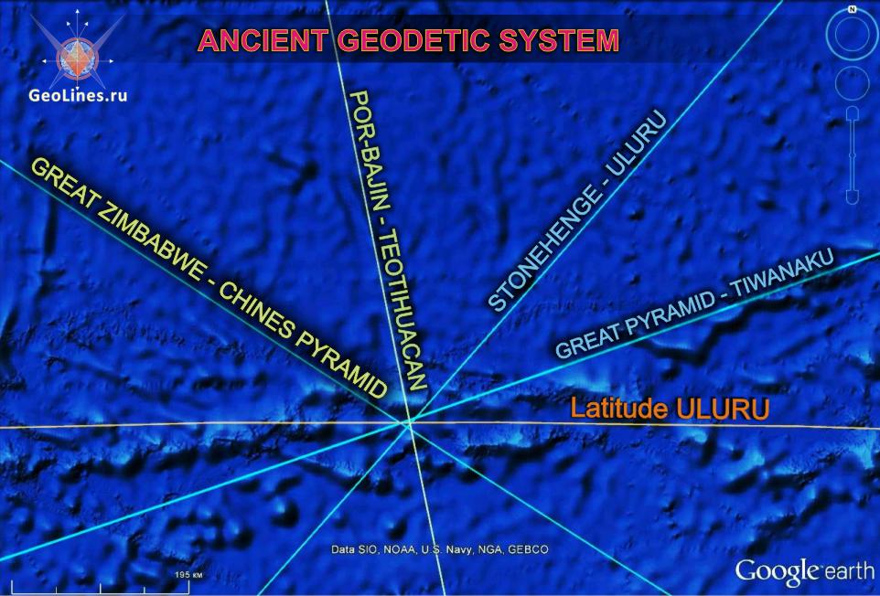
The system of ancient monumental constructions (SAMC) consists of several subsystems, like nested one to other. One of major subsystems is a system of latitudes and longitudes, which is formed owing to unique relative position of key historical objects. In this system, the Great Pyramid (GP) is starting point of count and its meridian is zero and latitude is 30th latitude of the Earth.
Starting from GP meridian, meridians of Uluru, Teotihuacan, Tiwanaku and Easter Island (EI), give 10-degree division of equator and Baalbek and Samaipata 5-degree division. Meridians of other important points of the system - Stonehenge, Nan Madol (NM) and Angkor are tied to the source meridians according to the correct geometrical figures. (See. "GEODESY OF MERIDIAN").
|
 Besides, the latitudes and meridians of listed objects are located relatively to each other so they form a symmetrical networks consisting of lines - great circles, which are diagonals of convex rectangles obtained with intersection of meridians and latitudes. (See. "LATITUDES OF HISTORICAL OBJECTS"). Besides, the latitudes and meridians of listed objects are located relatively to each other so they form a symmetrical networks consisting of lines - great circles, which are diagonals of convex rectangles obtained with intersection of meridians and latitudes. (See. "LATITUDES OF HISTORICAL OBJECTS"). |
 The simplest symmetrical network is formed from starting point - GP, by means of dividing equator on 8 equal parts with conditional meridians, i.e. multiply to 45 °, starting from meridian of GP, 30th latitude in the northern hemisphere, that is, latitude of GP, the equator and 30th latitude in the southern hemisphere form 16 convex rectangles, symmetrical relatively to equator. On diagonals of these rectangles lie the following objects - EI, Angkor, Uluru and Nan Madol. For more information about the network, see the end of the article "THE UNIVERSAL NAVIGATION SYSTEM." The simplest symmetrical network is formed from starting point - GP, by means of dividing equator on 8 equal parts with conditional meridians, i.e. multiply to 45 °, starting from meridian of GP, 30th latitude in the northern hemisphere, that is, latitude of GP, the equator and 30th latitude in the southern hemisphere form 16 convex rectangles, symmetrical relatively to equator. On diagonals of these rectangles lie the following objects - EI, Angkor, Uluru and Nan Madol. For more information about the network, see the end of the article "THE UNIVERSAL NAVIGATION SYSTEM." |
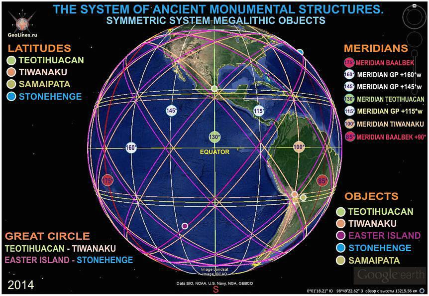
Another unique symmetrical network, which also is tied to GP, form EI, Stonehenge, Tiwanaku and Teotihuacan. See. Article "SYMMETRIC SYSTEM OF PYRAMIDS." |
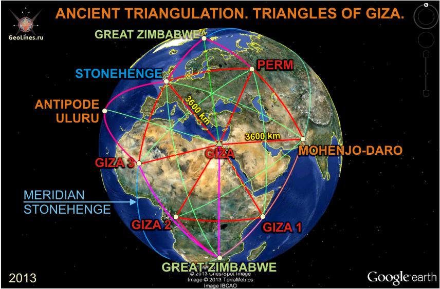
Another subsystem is system of triangles, which resembles modern network of triangulation and covers the whole planet. The system consists of regular triangles in whose tops are all the same key historical objects. In this system, there are conditional 5 points - Perm, Giza1,2,3 and Great Zimbabwe, which were obtained by means of constructions from original objects. The validity of these points is confirmed with numerous laws.
Stonehenge and Mohenjo-daro (MD) set around Great Pyramid equilateral triangles adjacent with isosceles triangles, which form Great Zimbabwe (GZ) and antipode of Uluru. See. "TRIANGLES OF GIZA."
|
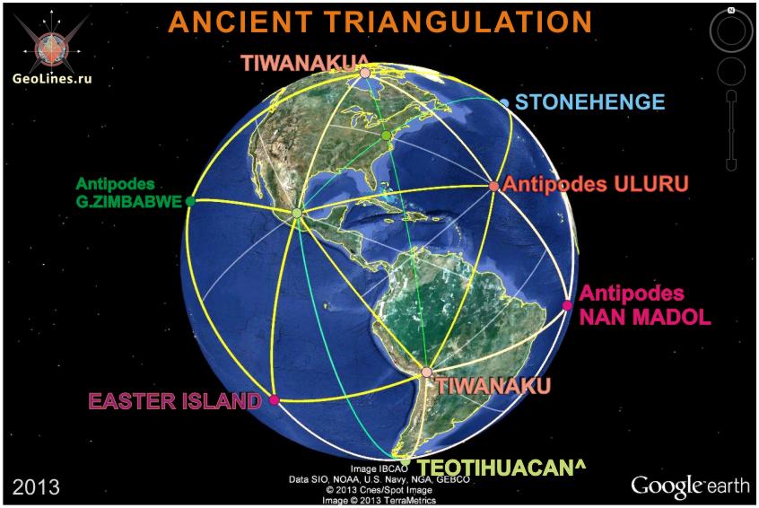
In the west, Teotihuacan, Tiwanaku, EI, point-antipodes GZ, Nan Madol and Uluru, form another system of regular triangles this time – isosceles ones. Thus, points of Uluru and GZ bind both systems, and the distance between them is equal to 10014 kilometers, or exactly ¼ circle the Globe. See. "SYSTEM OF TRIANGLES". |
|
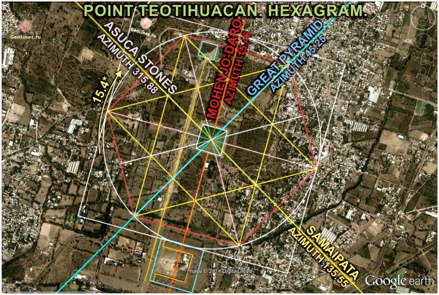
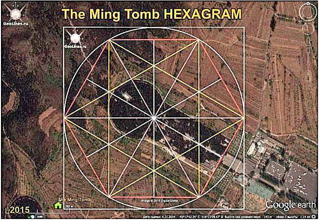
Another important subsystem is system of azimuths, the meaning of which is that the angles between the directions on key points of (SAMC), in all major points correspond to the angles of correct geometrical figures - hexagram, pentagram, etc.
In other words, azimuth to main objects of system in key points are located according to right figures, forming different combinations.
Imposing these combinations one on another in a certain order, you can determine the directions to main objects without resorting to measuring and geodesic systems. See. "HOW TO DETERMINE IN SAINT PETERSBURG DIRECTIONS TO THE MOST MYSTERIOUS CONSTRUCTIONS OF EARTH". |
|
Another a very important moment is connected with azimuths. The fact is that some values of azimuths for certain pairs of objects coincide with azimuths for other pairs of objects. For example, if you stand on Great Pyramid and look at Stonehenge, it does not matter if to stand in Tiwanaku and look at Teotihuacan. Or standing on Uluru, also look at Stonehenge. If you look from Great Pyramid at Angkor, it is like looking from Stonehenge at Mohenjo-Daro, or from Uluru look at Teotihuacan, or Kailas to Mecca. If you stand on the GP and look at Easter Island, it is like standing in Stonehenge also look at Easter Island. See. «АЗИМУТЫ ИСТОРИЧЕСКИХ ОБЪЕКТОВ И РАССТОЯНИЯ МЕЖДУ НИМИ».
|
 Overwhelming majority of ancient buildings, regardless of the continent and time of construction, themselves inherently are navigation systems, which are oriented often designed according to the correct geometrical figures. With help of layout and orientation, information is laid to them allowing to determine its location in space for observation of the object. Most likely, this is the main purpose of these pyramids, temples and other megalithic structures. See. «ДРЕВНИЕ НАВИГАЦИОННЫЕ КОМПЛЕКСЫ». Overwhelming majority of ancient buildings, regardless of the continent and time of construction, themselves inherently are navigation systems, which are oriented often designed according to the correct geometrical figures. With help of layout and orientation, information is laid to them allowing to determine its location in space for observation of the object. Most likely, this is the main purpose of these pyramids, temples and other megalithic structures. See. «ДРЕВНИЕ НАВИГАЦИОННЫЕ КОМПЛЕКСЫ». |
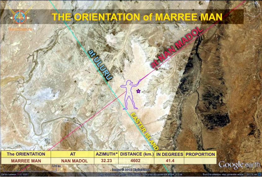 There is also a subsystem of orientation when some objects are oriented to other objects. For example, a road of dead in Teotihuacan is the precise orientation to Mohenjo-daro. See. "ORIENTATIONS OF HISTORICAL OBJECTS". There is also a subsystem of orientation when some objects are oriented to other objects. For example, a road of dead in Teotihuacan is the precise orientation to Mohenjo-daro. See. "ORIENTATIONS OF HISTORICAL OBJECTS". |
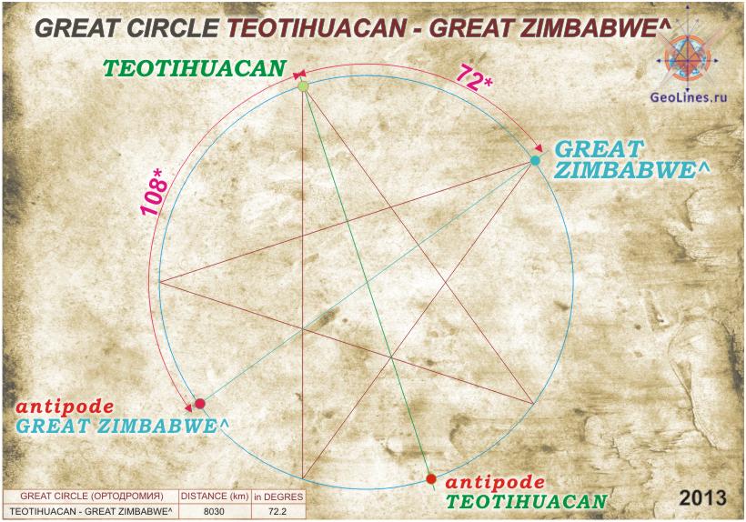 Some more number of laws clearly are observed in the distances between objects. Very often, the distances, expressed in degrees, also correspond to the angles of regular geometric figures, for example, hexagram and pentagram. More often identical distances between the objects are found. See. "SOME FEATURES OF DISTANCES BETWEEN INDIVIDUAL HISTORICAL OBJECTS" Some more number of laws clearly are observed in the distances between objects. Very often, the distances, expressed in degrees, also correspond to the angles of regular geometric figures, for example, hexagram and pentagram. More often identical distances between the objects are found. See. "SOME FEATURES OF DISTANCES BETWEEN INDIVIDUAL HISTORICAL OBJECTS" |
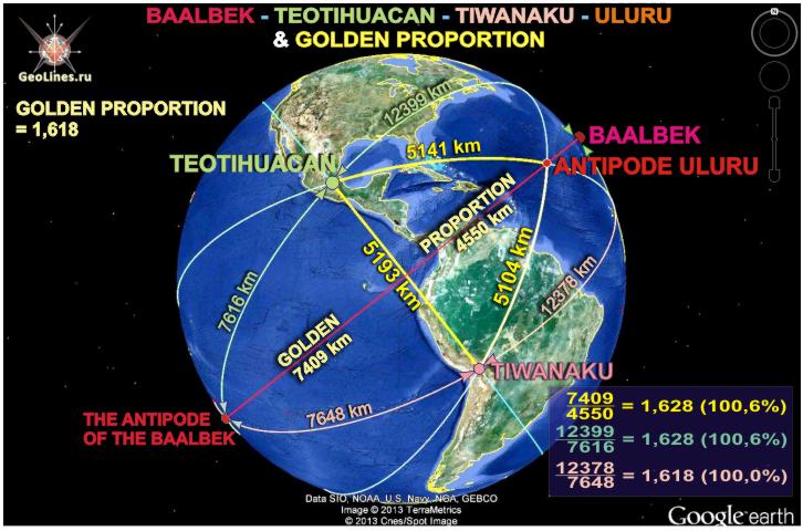
Many pairs of historical objects are equidistant from the third point. For example, Teotihuacan and Tiwanaku are equidistant from Baalbek, and in the golden section, as well as Teotihuacan and Nazca are equidistant from Great Pyramid also in the golden section. Accordingly, Baalbek and GP are equidistant from Teotihuacan. |
Besides, there are laws connected with the lines, which join conditionally the main objects of (SAMC). These lines intersect in a certain way in certain places, possibly form another subsystem - a system of large circles - the Great Circle. See. "GREAT CIRCLES - LINES GREAT CIRCLES" |
|
There is also plenty of unique laws, linking with variety of ways both some historical objects and the whole groups.
|
It is harder to say about appointment of systems because this is the area of ??assumptions. But, some moments can be traced quite clearly. Based on the foregoing most likely, (SAMC) is a versatile navigation system for flying over the planet, based on different principles, without coordinate system. The main navigation elements of this system are pyramids, temples and other megalithic structures, which are placed on the planet in such a way that observation one of objects allows to determine where are all the others, as well as its position in space. Since most of ancient constructions are tied to the solar and lunar cycles, i.e. a known starting point in theory you can generally determine your position in the solar system in particular time.
But, most likely (SAMC) is multifunctional. For example, knowing primordial position of the objects you can trace the movement of lithospheric plates, following for change in distances and angles between the directions. According to the present position of objects, knowing how the plates move you can roughly determine the creation of the system countdown. Perhaps the ancient buildings were used for communication or generation of certain types of energy.
It is logically to assume that the system of ancient structures was created a highly developed civilization or civilizations, for the millennial use (therefore all the buildings are so monumental). For such periods and in order that the system can be used by all to whom it is intended, (SAMC) has been saved and scathed graphically using lines and geometric figures on Nazca plateau.
|
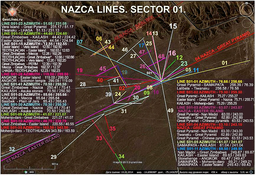 Most of the lines, with accuracy up to hundredth correspond to a particular azimuth between real historical objects, which are grouped logically in combinations also corresponding real ones. Most of the lines, with accuracy up to hundredth correspond to a particular azimuth between real historical objects, which are grouped logically in combinations also corresponding real ones. |
Obviously the designated point are centers, which are present set on Nazca depending on combinations and signifies particular historical object. And depending on this are issued the necessary directions. For example, if at given moment particular point is Stonehenge then certain points around become the other objects, for which fulfills the loyalty of directions. Further, from newly obtained points you can get new true azimuths combination with other points and figures on plateau, thus developing the system.
In addition, the system of Nazca lines can be most likely multilayer. In this case, one and the same point, in different layers can represent different historical objects.
Gradually system in Nazca should withdraw on itself. Then, as in reality, defining a single point or line in Nazca you can get all information at once. But, at the moment, it is not fully understandable yet logic of constructions, just stating a fact that location of centers and lines in Nazca desert, corresponds to the real combination of azimuths between specific historical objects.
On what is the algorithm are combined geoglyphs in Nazca it is not clear yet, but it is clear that the principle is connected with mathematical laws and spherical geometry.
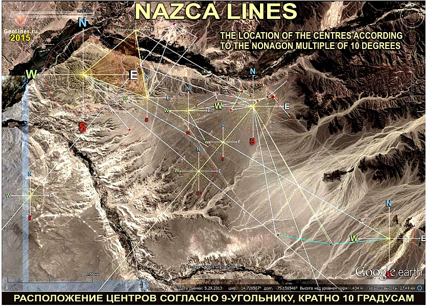
In the desert of Nazca, the location of major centers, azimuths of many lines, as well as the angles between them, match the angles of regular geometric figures. The proportions and angles of hexagram, pentagram, octagon and nonagon are found everywhere. Therefore, we can assume that algorithm for constructing the (SAMC) is connected with correct proportions of figures, which can be expressed through each other. Universal coefficient for this, along with the golden ratio (1.618) is the number 0.666. For example, 45 x 0.666 = 30, 30 = 0.666 x 20 72 / 0.666 = 108, 72/45 = 1.6. |
 It is possible assume that in Nazca are marked the whole area of ??the Earth which are tied to specific key points in the system. It is possible assume that in Nazca are marked the whole area of ??the Earth which are tied to specific key points in the system.
Since all this is marked on plane, only by means of azimuths and possibly distances in the desert they had to draw a lot of points, lines and figures corresponding to a particular object. But, because these objects were originally located on the planet according to system, strictly in certain places, there is no confusion, and the system displays the information you need.
This is very similar to a modern "bar code", decrypts the information of which the phone decrypts automatically, as it contains a reading algorithm. Similarly, knowing the algorithm automatically is read the information on Nazca. Similarly likely is read information from "crop circles."
Thus, based on the foregoing, it can be assumed, that geoglyphs in Nazca is a versatile flight card, which allows you to orientate, to move and find a desirable points on the planet. |
Author: © GeoLines.ru
|

 Sensational! Tens of thousands of unknown geoglyphs have been found in the Sahara.


